Navy favors massive project with 10K housing units on NAVWAR site

In environmental analysis, the federal agency identifies a 19.6 million square-foot development plan that would add 14,364 residents and 70,000 daily car trips as its first — but not final — choice for the 70-acre site
The Navy has determined it would like to work alongside private developers to replace its familiar-but-obsolete hangars along Interstate 5 with new facilities, thousands of homes, plenty of office space for large companies, two hotels and community shops in towers stretching as high as 350 feet — with a transit center to boot.
The preliminary decision for the 70-acre site in the Midway District, commonly referred to as NAVWAR, was published Friday by the United States Department of the Navy in what’s known as a draft environmental impact statement.
Jennifer Van Grove discusses this story on the San Diego News Fix:
The 730-page document, now available to the public for a 60-day comment period, considers the impacts of five scenarios of varying intensity on things such as traffic, views and air quality. The report, required by the National Environmental Policy Act, identifies the highest-density plan, which would introduce 10,000 homes and 70,000 more car trips per day to the area at buildout, as the Navy’s first — but not final — choice for the property.
“This makes good business sense. This project takes what is federal property, spread out on the first floor of 70 acres, and gives the opportunity to monetize the value of that 70 acres to provide the Navy with new, modern facilities that are secure to support our mission. And, at the same time, allowing housing and transit-oriented development to take place on what is currently federal land,” said Greg Geisen, who is the project manager for the NAVWAR revitalization effort.
“That is ground-breaking in the sense of a partnership between the community and the Navy to both win.”

Referred to as “alternative four,” the preferred development scenario encompasses 19.6 million square feet of total development spread across 109 buildings and two parking structures, all built over a 30-year period.
In this instance, the Navy requires 1.7 million square feet for all-new cybersecurity buildings and employee parking spots, with its portion to be built by a private partner within the first five years. The developer could then use, in exchange, the remaining square footage for a massive, mixed-use development dominated by housing.
Some 75 percent of all square footage would be dedicated to apartments and parking spaces for residents — or 10,000 units (and 14,400 parking stalls) for a potential neighborhood population increase of 14,364 people. The plan also calls for 1.35 million square feet of commercial office space, 250,000 square feet of mostly ground-level stores, a 140,000 square-foot transit center with 500 parking spots and two hotels offering a total of 450 rooms.
After construction, the annual gross county product is estimated at $1.9 billion in 2020 dollars. The scenario would also generate $154 million in local and state government revenue from a new tax base.
Owned by the Navy since the mid-90s, the Naval Base Point Loma, Old Town Complex is home to the military’s Naval Information Warfare Systems Command and Naval Information Warfare Center Pacific divisions. The groups — a mix of 6,000 full-time and contract cybersecurity professionals — work in World War II-era hangars deemed by the federal agency to be beyond their useful life. Many of the buildings have sewage problems and leaky roofs, presenting far from ideal conditions for a defense operation that supports 700,000 network users, is said to combat 8 million cyberintrusion attempts per day and needs to recruit a highly skilled workforce.
“These things were built in the 1940s to assemble B-24 bombers. So in many cases, you’ve got a building within a building, because the building itself does not lend itself well to the mission that NAVWAR has,” said Capt. Kenneth Franklin, who is the Commanding Officer of Naval Base Point Loma. “As the mission progresses, and NAVWAR’s facility requirements continue to evolve, we have to evolve with that changing requirement.”
The new facility push started in earnest in September of 2018 when the Navy first tested the private sector’s interest in the site. In 2019, the Navy contractually joined forces with the San Diego Association of Governments, with both agreeing to study the prospect of an airport-serving transit station in addition to a mixed-use project on the property. In 2020, the parties said they would work toward a land transfer, although a transaction remains out of reach until SANDAG can identify funding.

Still, the Navy’s preference for a high-density, transit-centered development matches perfectly with SANDAG’s desire for a “Grand Central Station” that connects all rail and bus lines with a people mover to the airport. Whether the public agrees remains to be determined.
The Navy’s draft environmental analysis finds that the preferred proposed development would create significant impacts in five out of the 16 different areas studied: transportation, visual resources, land use, environmental justice and noise.
For instance, many of the envisioned uses are greater, sometimes far greater, in intensity than those represented in the Midway District’s recently adopted community plan. And, when it comes to traffic, the Navy estimates that the desired scenario would create 70,022 new daily car trips by 2050, causing additional congestion at 26 intersections, 25 street segments, 10 freeway segments and one freeway on-ramp.
The report also finds that views across the NAVWAR property would be greatly impacted as well, particularly when looking toward Mission Bay and the University of San Diego.
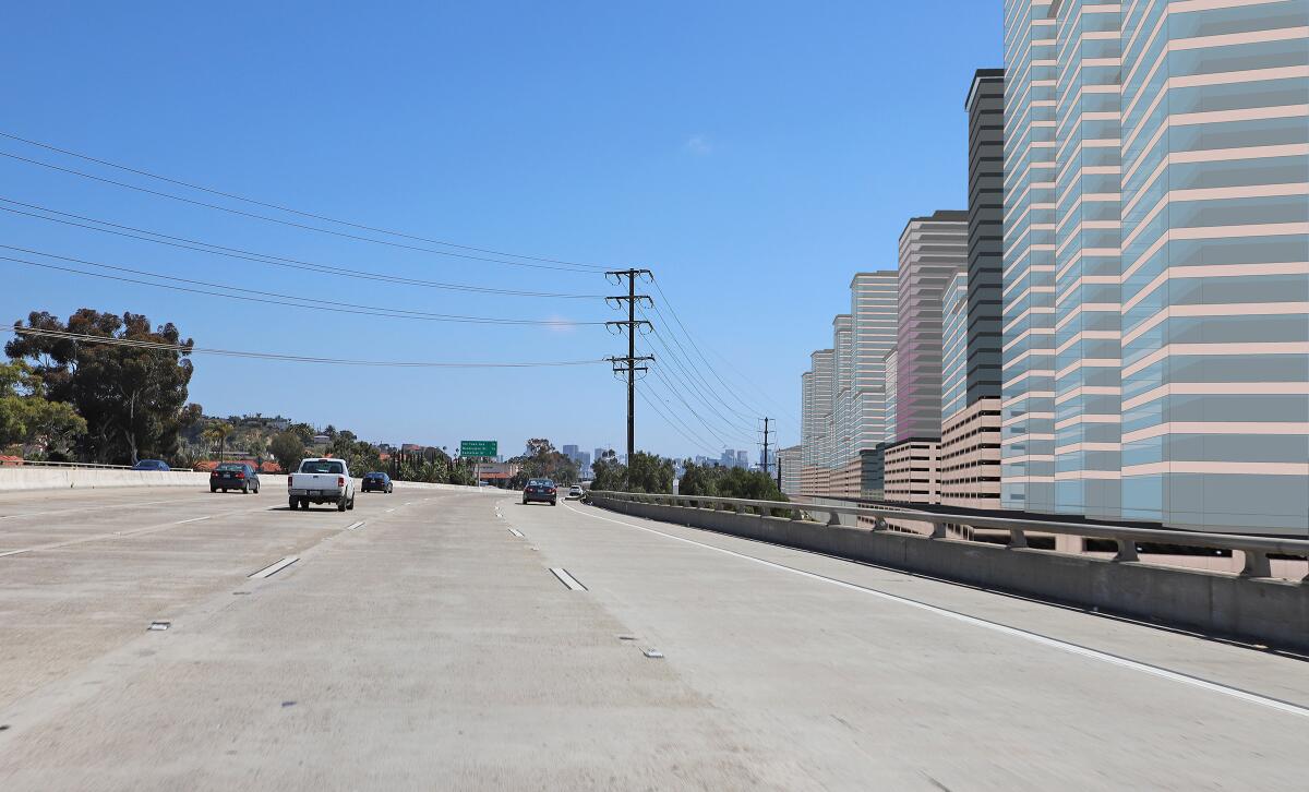
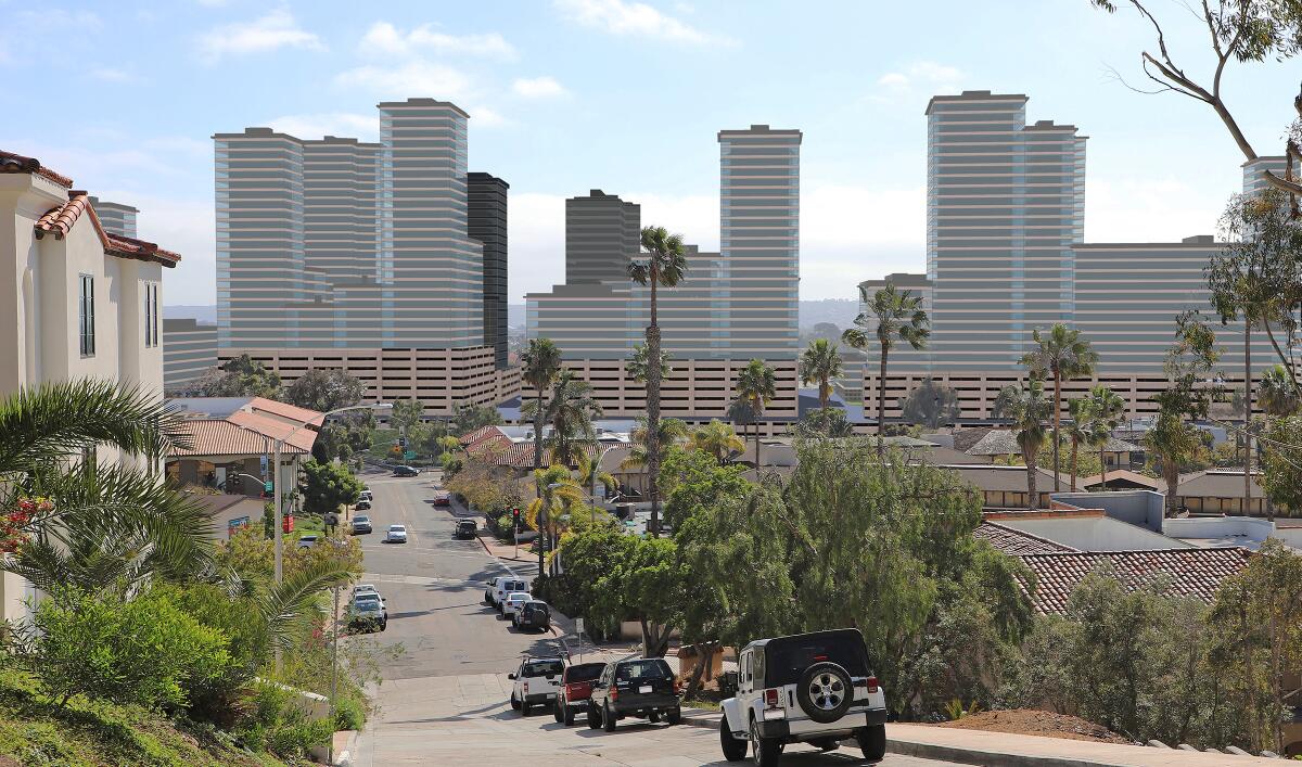
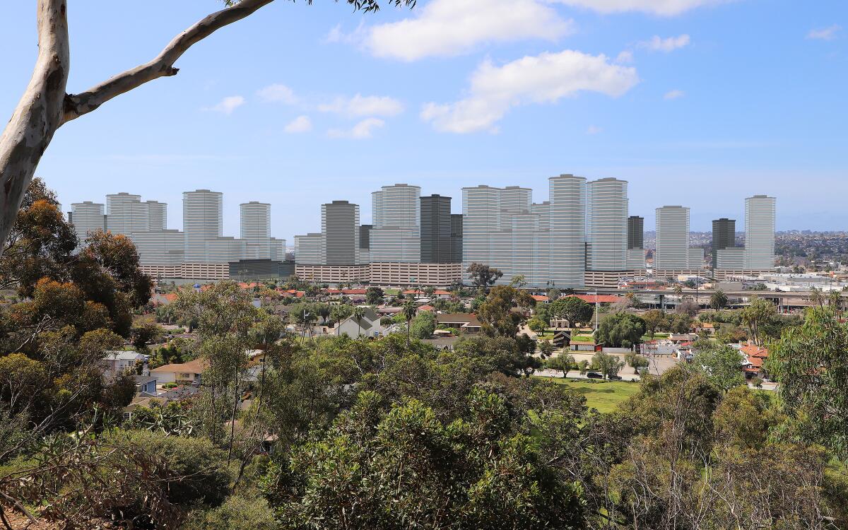
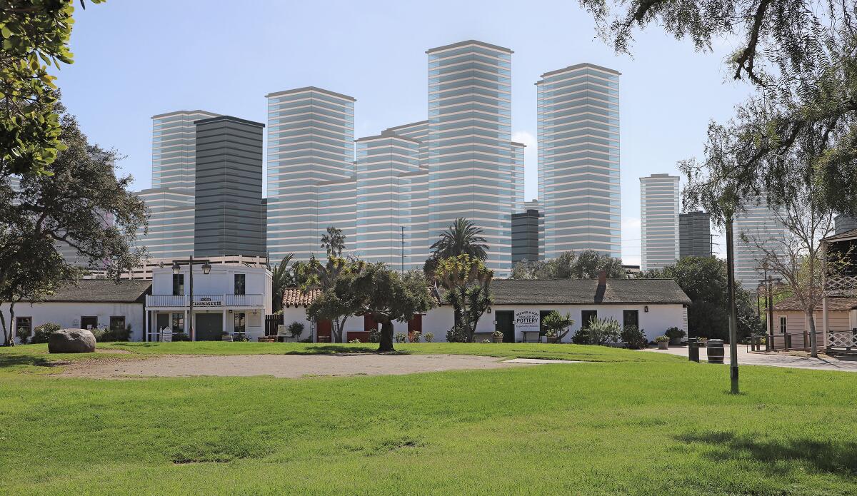
Visual simulations, pairing real-world photography with modeled building heights, suggest a wall of high-rises along Interstate 5 that would not only block drivers’ scenic views of Point Loma and beyond, but tower over Old Town and interfere with sunsets from Mission Hills.
The plan is estimated to block 44 percent of views of the Point Loma Hillside, 36 percent of views of the southwest Pacific Ocean and 12 percent of views of the downtown skyline. The average view blocked across 10 different viewing scenes was 37 percent, the document states. The scenario would also give 70,000 more people within a 3-mile radius the ability to see buildings on the NAVWAR property.

In the realm of environmental justice considerations, the analysis noted that low-income and minority groups living nearby would likely bear the brunt of traffic issues.
“Residents of the areas in the immediate vicinity of (the NAVWAR site) would be most strongly affected as most travel tends to be close to home,” the report states. “The areas in the immediate vicinity of (the NAVWAR site) are either low-income or minority areas, and therefore low-income and minority populations would tend to experience adverse effects disproportionately.”
The analysis also studied alternatives with fewer impacts, including just a Navy-funded renovation plan with limited demolition and construction, as well as options without a transit center. The federal agency is not yet committed to any one option and will make a decision after considering public input and publishing a final environmental impact statement, likely around the end of the year.
Community members, government agencies and other groups are being asked to weigh in on the draft environment analysis between now and July 13. The Navy has also scheduled two virtual public meetings for June 8 and June 23, with additional information available at NAVWAR-revitalization.com.
Get U-T Business in your inbox on Mondays
Get ready for your week with the week’s top business stories from San Diego and California, in your inbox Monday mornings.
You may occasionally receive promotional content from the San Diego Union-Tribune.
