Towards an International Levee Performance Database (ILPD) and Its Use for Macro-Scale Analysis of Levee Breaches and Failures


Department of Hydraulic Engineering, Faculty of Civil Engineering and Geosciences, Delft University of Technology, 2628 CN Delft, The Netherlands
*
Author to whom correspondence should be addressed.
Water 2020, 12(1), 119; https://doi.org/10.3390/w12010119
Submission received: 2 December 2019
/
Revised: 20 December 2019
/
Accepted: 22 December 2019
/
Published: 30 December 2019
(This article belongs to the Special Issue Flood Risk Assessments: Applications and Uncertainties)
Abstract
:Understanding levee failures can be significantly improved by analysing historical failures, experiments and performance observations. Individual efforts have been undertaken to document flood defence failures but no systematically gathered large scale, open access dataset is currently available for thorough scientific research. Here, we introduce an efficiently structured, global database, called International Levee Performance Database (ILPD), which aims to become a valuable knowledge platform in the field of levee safety. It comprises information on levee characteristics, failure mechanisms, geotechnical investigations and breach processes for more than 1500 cases (October 2019). We provide a macro-scale analysis of the available data, aiming to provide insights on levee behaviour based on historical records. We outline common failure mechanisms of which external erosion is identified as the most frequent for levees. As an example, we investigate flood events occurred in Germany (2002, 2013) and examine breach characteristics of hundreds of failures. It is found that initial failure mechanisms have an influence on breach characteristics and that failures due to instability and internal erosion are less frequent but lead to larger breaches. Moreover, a relation between the return period and the expected breach density during a flood event is identified. These insights could complement flood risk assessments.
1. Introduction
The majority of the global population is located in flood prone coastal areas and deltas. Between 1980 and 2015, 3563 flood events have been reported in Europe and more severe floods are expected in the near future [1,2]. Flood defence failures can lead to major catastrophes in terms of loss of life and economic damage. Improved flood defence measures are required to safeguard flood prone areas from floods in order to save many lives and avoid considerable damage costs. Aiming to prevent this, flood prone countries make substantial investments in activities related to monitoring, maintenance and reinforcement of flood defences. However, our understanding of levee failure mechanisms is still limited. Despite extensive research on individual mechanisms and processes of failures, the composition of levees, their behaviour during critical conditions and the modelling of their failures still remain uncertain [3]. There is a need for better validation and calibration of models or, in other words, better insight in their uncertainty.
Since the full-scale experiments are challenging and costly and the spatial variability in subsoil typically plays an important role, historical levee failures can be used to provide insights into the real failure processes and conditions. However, most of the analyses are performed with limited data from failed levees, since most of the evidence is washed away during real failures. This highlights the need for systematically and globally collected data and a sharing platform not only to advance understanding of levee failures and their mechanisms but also to improve failure and breaching models. These insights could eventually contribute to the development of accurate techniques for innovative designs of flood defence systems and support decisions and actions affecting levee safety [4].
Several databases and data collections already exist in the field of dam safety (Table 1). Apart from general information on the available dams around the world [5,6], these databases may have a particular focus on dam breaches [7,8], landslide dam failures [9], large dam failures [10], internal erosion of dams [11], dam incidents [12] and loss of life for risk assessments [13,14]. Most of these databases include general information about the dams, such as geometry, type, reservoir capacity and in some cases information on their failures, for example, time to failure, breach information, peak discharge. Databases are also used for the analysis of accident statistics in other fields of Civil Engineering. Typical examples include global reports on natural disaster impacts and frequencies [15], remote sensing-based flood information [16] or data on flood protection standards [17].
In the field of levee safety, there is a small number of open access databases with some information available, see Table 1. Some online databases provide general information on levees at a regional [18] or at a national level without a particular focus on their failures [19,20]. Individual efforts have been undertaken to document levee failures after disasters, for example, New Orleans in 2005 [21,22], Germany in 2002 [23] but no systematically gathered large scale, open access datasets are available for thorough scientific research. In this dearth of information, some researchers have constructed data collections specifically on levee failures [24,25]. Characteristic of these mostly table-formatted databases is that only generic information on failures is provided, for example, general information on the levee geometry, material, breach information, failure mechanism. The databases identified for levees do not include any detailed geotechnical or hydraulic information that would allow more in-depth analysis of historical failures. This limits the use of these databases for detailed analysis of the failure processes, development of empirical levee breach models or validation of process-based models.
Aiming to improve the understanding of these failure mechanisms and breaching and to enhance the reliability analyses of flood defences, we set up an International Levee Performance Database (ILPD) to facilitate sharing of data on levee characteristics, failure mechanisms, geotechnical investigations and breach processes. The objectives of this study are (1) to present a comprehensive overview of the first version of the ILPD (containing more than 1500 cases) and (2) to perform a macro-scale analysis of the available data on levee failures and breaches, aiming to demonstrate the potential of the database in providing insights on levee behaviour and supporting flood risk assessments based on historical records. First, we elaborate on the purpose and structure of the ILPD and establish a terminology which is used for describing levee failures. We provide basic statistics on the currently (October 2019) available ILPD data to illustrate the overall characteristics of the database. Second, as an example for the use of a sub-dataset from the ILPD, we investigate the flood events in Germany, occurred in 2002 and 2013 and examine breach characteristics of over a hundred failures in order to outline the most common influence factors at an event-level. We also introduce two breach density parameters, which are related to the expected amount of levee breaches and their width, intended to be used for the risk assessment of levees. Finally, we highlight the operational obstacles and strategies to further improve the ILPD and discuss the use of event-level analysis for risk assessments.

Table 1.
An overview of the example databases in the field of flood risk, dam and levee safety.
| Database/Reference | Field of Application | Number of Cases | Failures Included | Data Type a | Accessibility | Active (Y/N) |
|---|---|---|---|---|---|---|
| Peng and Zhang [9] | Landslide dams | 1044 cases | Yes | General information | Open access | No |
| Utah State University database [13] | Dam failures | 174 cases | Yes | General information with a particular focus on loss of life data for dam safety risk assessments | Open access | No |
| Flood Protection Standards (FLOPROS) database [17] | Flood protection standards | 179 cases for design layer 68 cases for policy layer | No | Detailed information on design and policy standards (not on the actual flood defences or their failures) | Open access | No |
| Association of State Dam Safety Officials (ASDSO) database [12] | Dam failures | 14 detailed case studies | Yes | Detailed information such as photos, videos, general information and lesson learned, reports, failure mechanisms | Open access | No |
| United States Bureau of Reclamation (USBR) database [14] | Dam failures focused on loss of life | 60 cases | Yes | General information with a particular focus on loss of life | Open access | Yes |
| National Performance of Dams Program (NPDP) database [5] | Dam | >10,000 cases but few failure cases | Yes | General information including emergency plan, population at risk, storage capacity, failure mech., consequences, lessons learned | Open access | Yes |
| Dam Accident Database [6] | Dam failures | 900 cases | Yes | General information, including some detailed data (hydrographs, reports, photos, etc.) | Not publicly available | No |
| Dartmouth Flood Observatory of Large Floods [16] | Remote sensing-based flood information | 4700 flooding events | Yes | General information including duration of the event, loss of life, damage, severity, effected area, magnitude of the flood, etc. | Open access | Yes |
| The International Disaster Database (EM–DAT) [15] | Disaster, including flooding | >10,000 cases | No | Detailed information on the disaster related data | Open access | Yes |
| Froehlich [7] | Dam failures | 43 | Yes | General information on the breach formation | Not publicly available | No |
| Foster et al. [10] | Large dam failures | 136 | Yes | General information | Not publicly available | No |
| Xu [8] | Dam failures | 1443 cases | Yes | Detailed information | Not publicly available | No |
| ERINOH database [11] | Internal erosion of dams and levees | 120 failure cases | Yes | General information, also including some detailed data (hydrographs, breach info., reports, photos, maps, etc.) | Not publicly available | No |
| Van Baars and van Kempen [24] | Levee failures | 337 | Yes | General information | Not publicly available | No |
| Italian Levee Database (INLED) [19] | Levee information | Currently, a few cases | Yes | General information | Not publicly available | Yes |
| Danka [25] | Levee failures | 1004 cases | Yes | General information | Open access | No |
| Department of Water Resources (DWR) levee database [18] | Urban and non-urban levee failures in California | 215 cases | Yes | General information | Open access | No |
| U.S. Army Corps of Engineers database [20] | National levee information of USA | >10,000 cases (no separation for failures) | Yes | Detailed information on levee system evaluation and inspection, flood risk communication, flood plain management and risk assessment | Open access | Yes |
a General information includes geometry, construction time, type, failure mechanisms, capacity, material, peak outflow rate, breach information and also qualitative information.
2. Towards an International Levee Performance Database (ILPD)
2.1. Purpose of the ILPD
The main purpose of the ILPD is to provide a global platform for systematically collecting and sharing data on levee performances to facilitate research. Particularly, ILPD promotes (a) learning from what went wrong during past flood events to prevent floods from occurring in the future and (b) learning about how to model failure processes and how failure mechanisms might be correlated. By facilitating this, the database can also enable the systematic validation of models and the evaluation of model accuracy. More specifically, the ILPD has been developed to provide collected datasets on:
- Actual failures during extreme catastrophic events, such as levee failures in New Orleans, LA, USA [21] and failures during the levee construction phase;
- Failures in small- and full-scale experiments, such as levee breach experiments in the Netherlands [26];
- Detailed information on some earthen dam failures, as these show similarities with levee failures;
- Information on the consequences (e.g., damage, loss of life, flooded area, etc.) per extreme event.
2.2. The Design and the Structure
To allow for a wide range of data type and easy dissemination, the database is linked to a website from which data can be downloaded freely (leveefailures.tudelft.nl). All information stored in the ILPD is open access and sources are automatically provided along with the data upon downloading from the database.
Some extreme events, like Hurricane Katrina in 2005 or the 1953 floods in the Netherlands, caused multiple levee failures at different locations. To capture this, data is structured by events and failures, each associated to a unique ID’s in the ILPD. One event can consist of several individual failures, each containing specific data. The failure cases which are clustered in the same event are either caused by the same hazard event or are part of the same experimental program. This way, data on each specific levee failure adds to the understanding of the real failure processes, whereas information on the overall consequences, such as total damage or loss of life, can be linked to events.
The ILPD has a three-level structure with increasing degree of detail. The first level (Level.1: Metadata) provides general information on individual failure cases as well as on flood events in a table-based format (exportable to .csv files), for example historical levee failures in Hungary provided by [25]. This generic qualitative and numeric data may also include information on the consequences, such as total damage, loss of life and flooded area. Level.1 data mainly consists of information on the levee (geometry, location, material, type, etc.), flow boundary conditions (return periods, max. water level, peak flow discharge, etc.), breach (width, invert level, peak discharge, etc.), soil properties, management organization, documentation (video, photo, etc.) and references. The second level (Level.2: Intermediate) includes well-documented information on historical failures, such as loading conditions and soil profiles and modelling results; or hindcasted information based on field investigations of actual failures (e.g., New Orleans in 2005 [21,22]). The detailed information aims to provide more insight into the physical processes and to facilitate rapid analysis of failures. Since every dataset contains unique information, providing detailed data in a table-based format severely limits the ease of analysis of different datasets simultaneously. Thus, a more structured format is preferred in order to support rapid analysis of data from several detailed datasets (exportable into JSON files). Lastly, the third category (Level.3: In-depth) contains detailed information on failure processes including time-dependent data on the hydrodynamic loading conditions and geotechnical information. These dataset (exportable to .pdf/.csv files) mostly consist of experimental data, such as those provided by [29].
A screenshot of the opening page of the website is provided in Figure 1. The interactive map allows for navigation to all available failure cases. Each marker on the map represents the location of a failure case. Underneath, the cases pictured on the map are listed. When the case of interest is selected, basic information of the failure is presented and the media (if present) can be viewed. After selecting one or more cases, a click on the button ‘Export selection’ gives a pop-up window in which the type of data to be downloaded can be chosen. On the left side of the map, several filter criteria can be set. The database can be filtered based on time span, country, case study type, defence type or failure mechanism. Moreover, more filter criteria are available using the ‘Add filter criterion’ feature and a combination of different filter criteria can be made as well.
2.3. Categorization of Levee Failure Mechanisms
Given that various terminologies exist for levee failure mechanisms and other related parameters, a challenge in setting up an international database is to establish a list of uniform, globally acknowledged definitions. Flood defences are hydraulic structures whose primary objective is to provide flood protection along the coasts, rivers, lakes and other waterways [30]. A levee (also referred to dike or embankment) is a water retaining structure consisting of soil (fully or partly) with a sufficient elevation and strength to be able to retain the water under extreme circumstances [31]. A typical levee cross section is given in Figure 2. Earthen levees, which form a large part of the existing flood defence systems, can be constructed with (a) homogeneous soil (homogeneous earthfill), (b) several soil types (layered structure) or (c) a hard structure (levee structure combination), such as a levee with a floodwall. Examples of other types of flood defence systems are dams, dunes, storm surge barriers or temporary flood defences.
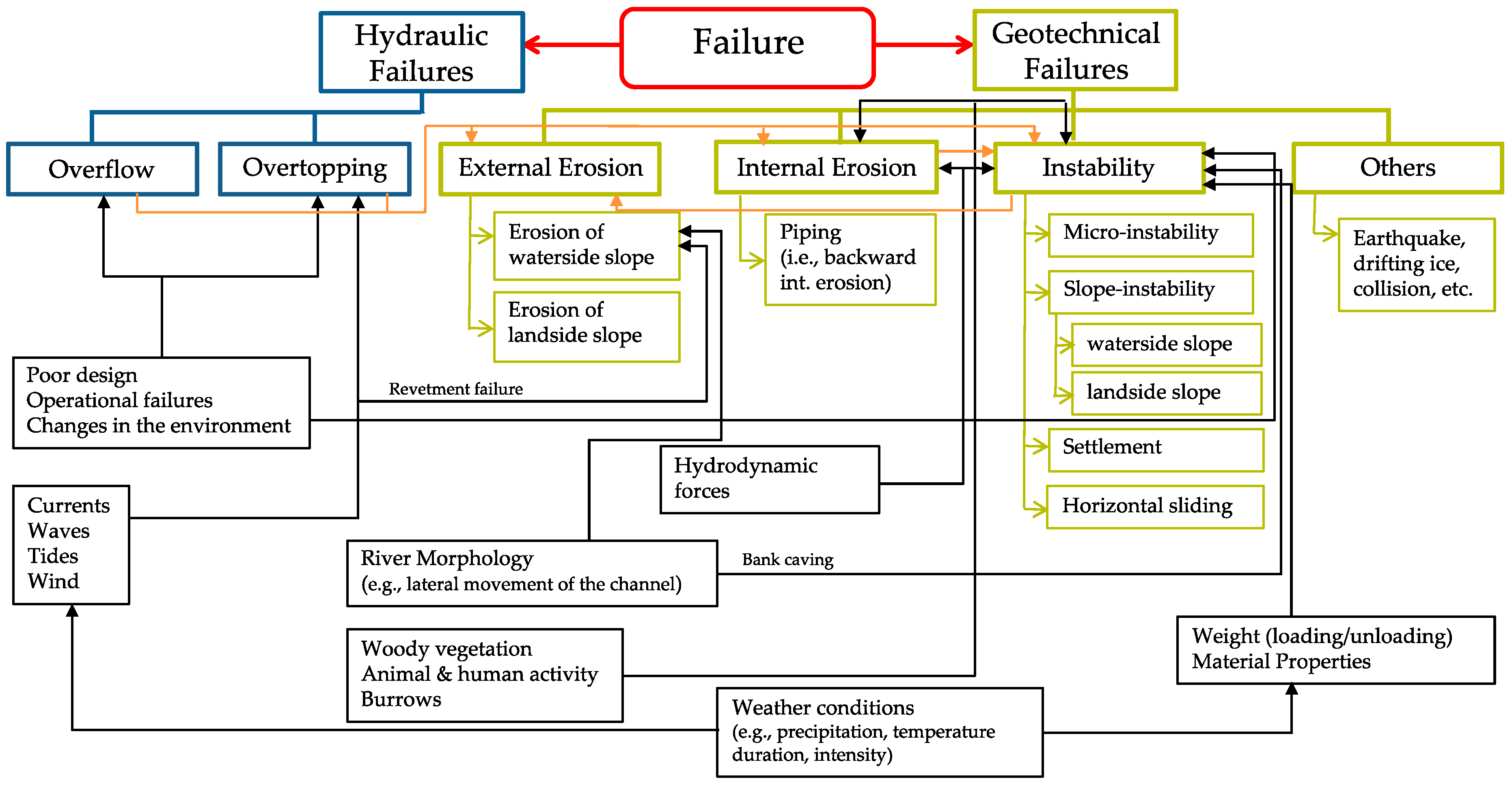
Levees can fail when their ultimate limit state is exceeded causing them no longer to fulfil their water retaining function [32]. The most commonly encountered levee failure mechanisms and their most common contributing factors are given in Figure 3 [31]. Hydraulic failures occur due to insufficient height, whereas insufficient strength leads to geotechnical failures [33]. Breaching of a levee refers to the loss of integrity or a major geometric change [32,34]. However, occurrence of a failure mechanism does not necessarily lead to a breach. For example, significant amount of overflow may cause severe floods without leading to a breach in the structure. Moreover, since the occurrence of the initial failure mechanism might trigger other mechanisms [33], a sequence of multiple failure mechanisms can be observed on the levee. For example, failures may be initiated with overtopping, followed by external erosion that causes a breach at the latter stage (Figure 3). All identified failure mechanisms are entered in the database in a chronological order.
The most relevant levee failure mechanisms observed in the database are defined briefly here [35].
- Overtopping and Overflow—Overflow occurs when still water level is higher than the crest level of the levee. Whereas, overtopping is observed when still water level remains below the crest level but waves run-up and pass the crest level.
- External erosion—External erosion occurs when the slope of the levee is not sufficiently resistant to the hydraulic loads, that is, when the shear stress induced by flows exceeds the critical value associated with the nature of the materials of the levee [31]. Currents and waves are the main aggravating factors of external erosion which can occur on the landside or waterside slope of the levee. Overtopping/overflow of a levee can induce major damages linked to external erosion, especially on the landside slope.
- Internal erosion—Internal erosion, which refers to a generic event, is initiated by hydrodynamic forces acting on soil particles within a levee foundation which are carried downstream by seepage flow [31]. In this process, migration of material particles induced by pore pressure and flow forms channels within the foundation soils. These pipes undermine the structure of the levee and lead to failure. Internal erosion related failure mechanisms consist of—concentrated leaks, backward erosion, contact erosion and suffusion [36]. Backward erosion, known as piping, is typically most relevant for levees. It occurs if uplift, seepage, heave and piping occur respectively. Seepage also increase the likelihood of instability because of changes to pore pressure distribution within the levee. Uplift pressure in foundation soils can generate major instability.
- Slope instability (i.e., instability)—Instability occurs when the forces (i.e., excess pore pressure) on a levee are higher than the shear resistance which is determined by the soil’s shear strength. Landside slope instability occurs due to the infiltration of water into the levee body and its foundation, leading to forcing of the levee body and decreasing shear strength of the soil. Whereas, waterside slope instability occurs due to sudden drawdown of the outside water level after heavy saturation of the levee body. In this situation, the pore pressures at the base of the potential slide plane stay high, while the horizontal pressure or support from the river water is reduced.
- Micro instability—Micro instability occurs when the seepage water causes the phreatic surface to rise and reach the waterside slope of a levee. The term “micro-” is used to distinguish the stability problems related to this phenomenon from the slope instability which essentially concern the whole levee body directly.
- Settlement—Settlement is a deformation mechanism in vertical direction that can mainly lead to insufficient crest height to prevent failure mechanisms like overtopping/overflow.
- Horizontal sliding—Similar to instability of the landside slope, sliding occurs along the base of the levee body. In this case, the main driving force is the horizontal force of the water exerted on the waterside slope. This mechanism is typically an issue for levees which are made of relatively light material such as peat, where the effective stresses at the base are very low.
3. Macro-Scale Analysis of Levee Failures
3.1. General Database Statistics
A large number of failure cases are collected all around the world and their basic statistics are reported in this section to provide an overview of the characteristics of the database. Currently (October 2019), the ILPD includes 1572 failure cases of which 1538 are the failures of flood defences occurred in different time periods and 34 of them are full- and small-scale experiments collected from different countries (Figure 4a). The available information mainly concerns the failures of levees (1418 cases) and levee structure combinations (14 cases) occurred along rivers (89%), coasts (10%) and canals (1%) but also of some earthen dams (106 cases) due to their similar composition to levees. The majority of the levee failures before 1900s mostly occurred in the Carpathian Basin in Hungary, as reported by [25,37] but these only contain generic information. The other cases reported in the ILPD, occurred in the last 100 years, are mostly from Germany, The Netherlands, USA, UK and Czech Republic (Figure 4b). It is noted (and further discussed in Section 4) that the geographical and temporal distributions shown in Figure 4 only represent the data currently included in the database.
Most failure entries in the database contain general information (Level.1: 1498 cases), such as levee and breach characteristics. As an example, Figure 5 shows that the crest height of the failed levees, which is defined as the differences between the toe level and the crest level, varies mostly between 1–5 m, whereas the crest width is in the range of 2–5 m. The database also includes more detailed information on the Level.2 (59 cases) and the Level.3 (14 cases) data.
Most of the events in the database are associated with single failures. However, 38% of the failures occurred during events (65 in total) with more than one failure. Examples for the documented events with the large number of breaches are in Germany (2002) with 111 failures, Netherlands (1953) with 97 failures and Czech Republic (1997) with 33 failures.
Failure Mechanisms
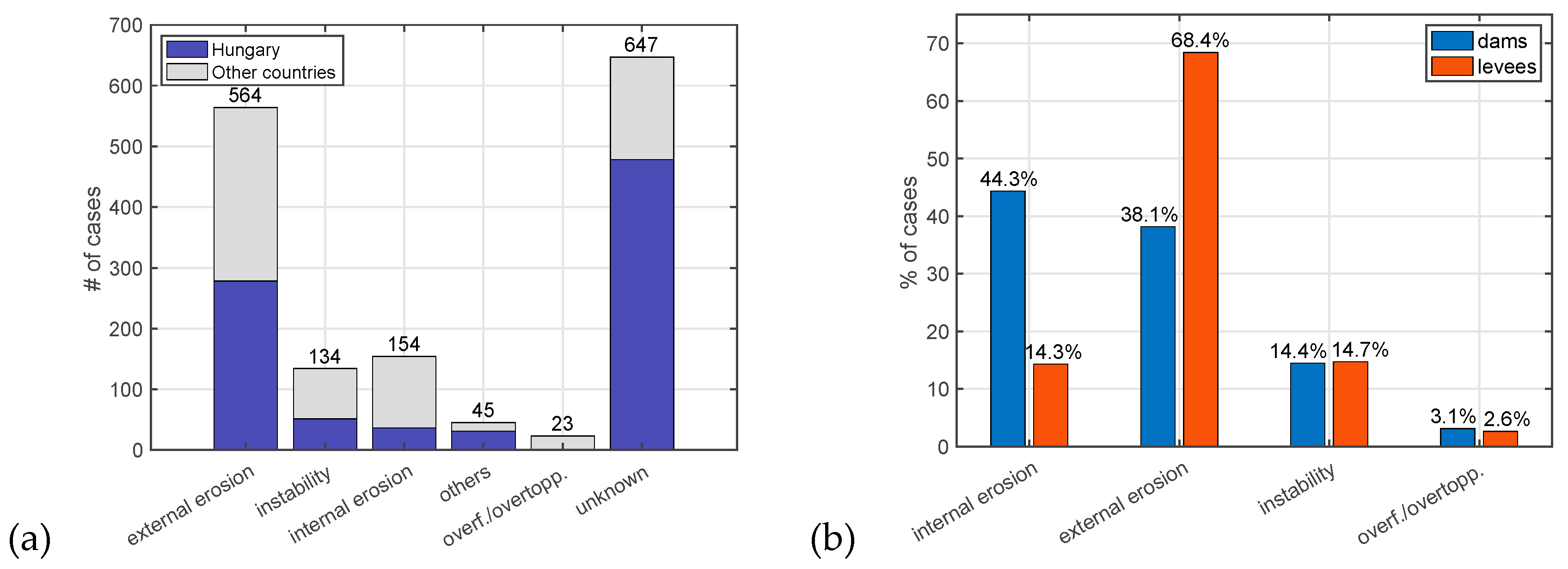
Analysis of the identified failure mechanisms within the collected cases in the database (Figure 6a) shows that more than half of the failures, of which their causes are known, occurred due to external erosion (61.5%), internal erosion (16.8%), instability (14.2%), overflow/overtopping (2.5%). Besides, the rest of the failures were due to other causes (4.7%), including man-made failures. It is noted that excluding the Hungary dataset [25], which forms the majority of the database, does not significantly affect this distribution (Figure 6a).
A comparison between observed failure mechanisms for levees and earthen dams (Figure 6b) reveals that external erosion of the slope is more likely to occur in levees. This can be explained by the fact that water level and discharge in rivers, as well as currents and waves in seas, are mostly affected by meteorological and hydrological conditions which are more uncertain than for dams. Whereas, water levels in the reservoirs behind dams are generally more controlled. Moreover, the reason for a more frequent occurrence of internal erosion in earthen dams is associated with the higher hydraulic head differences due to the larger size of dams.
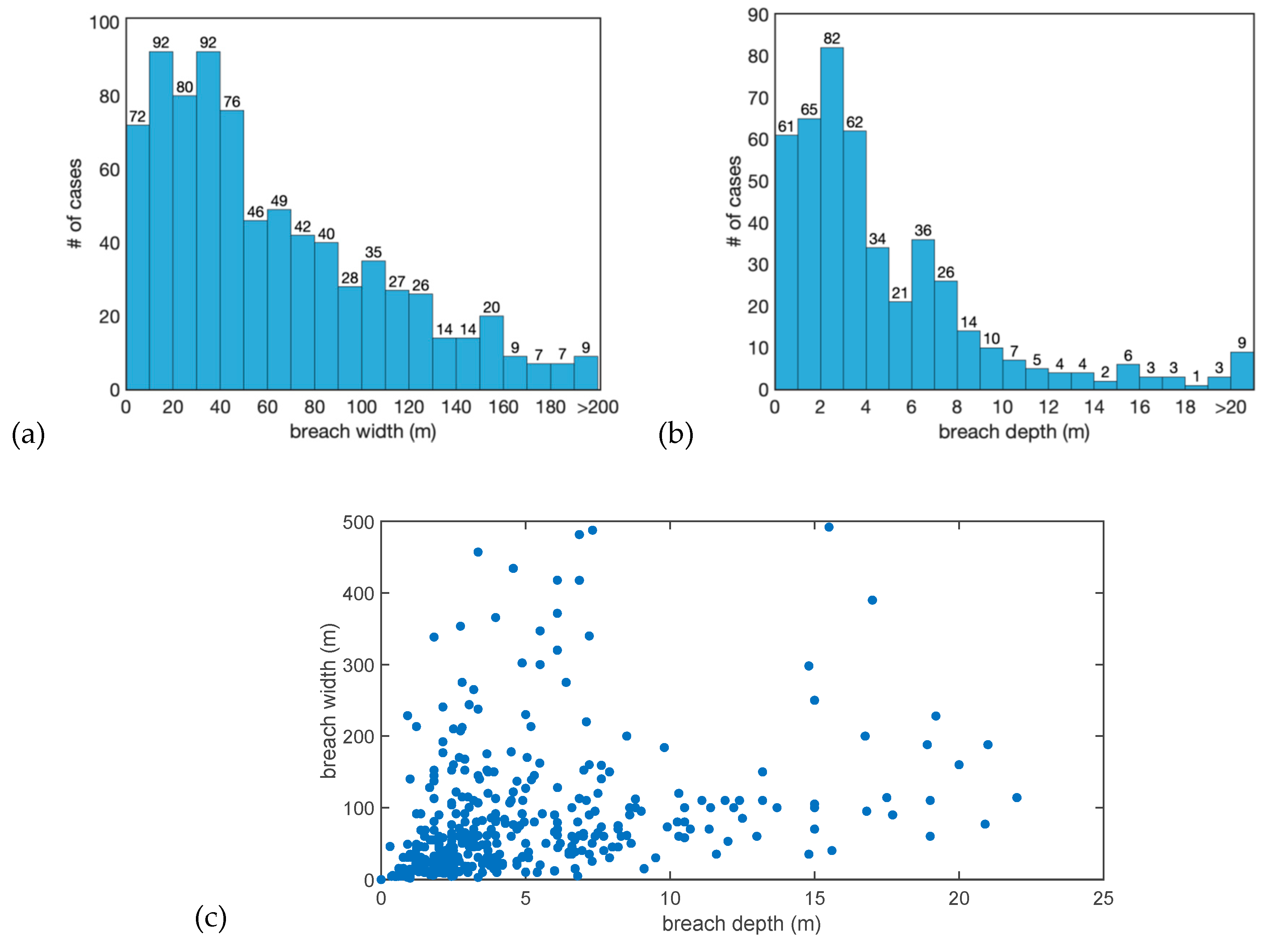
Levee breaching was observed for most of the failure cases that are entered in ILPD. Failures that did not lead to a breach at the later stage were mostly due to overflow/overtopping (23 cases). Information on the breach characteristics, given in Figure 7, shows that there is a considerable variation in breach depth and width values. Previous studies on breach models reveal that, under certain conditions, breach depth and width are correlated during some of the breach development stages [26,38]. However, breaching is a complex process that depends on many different factors (e.g., structure type, loading conditions, soil characteristics, etc.), thus the relation between breach depth and width may not always be explained by a simple relation model (Figure 7c).
3.2. Investigation of the 2002 and 2013 Failures in the Elbe Region, Germany
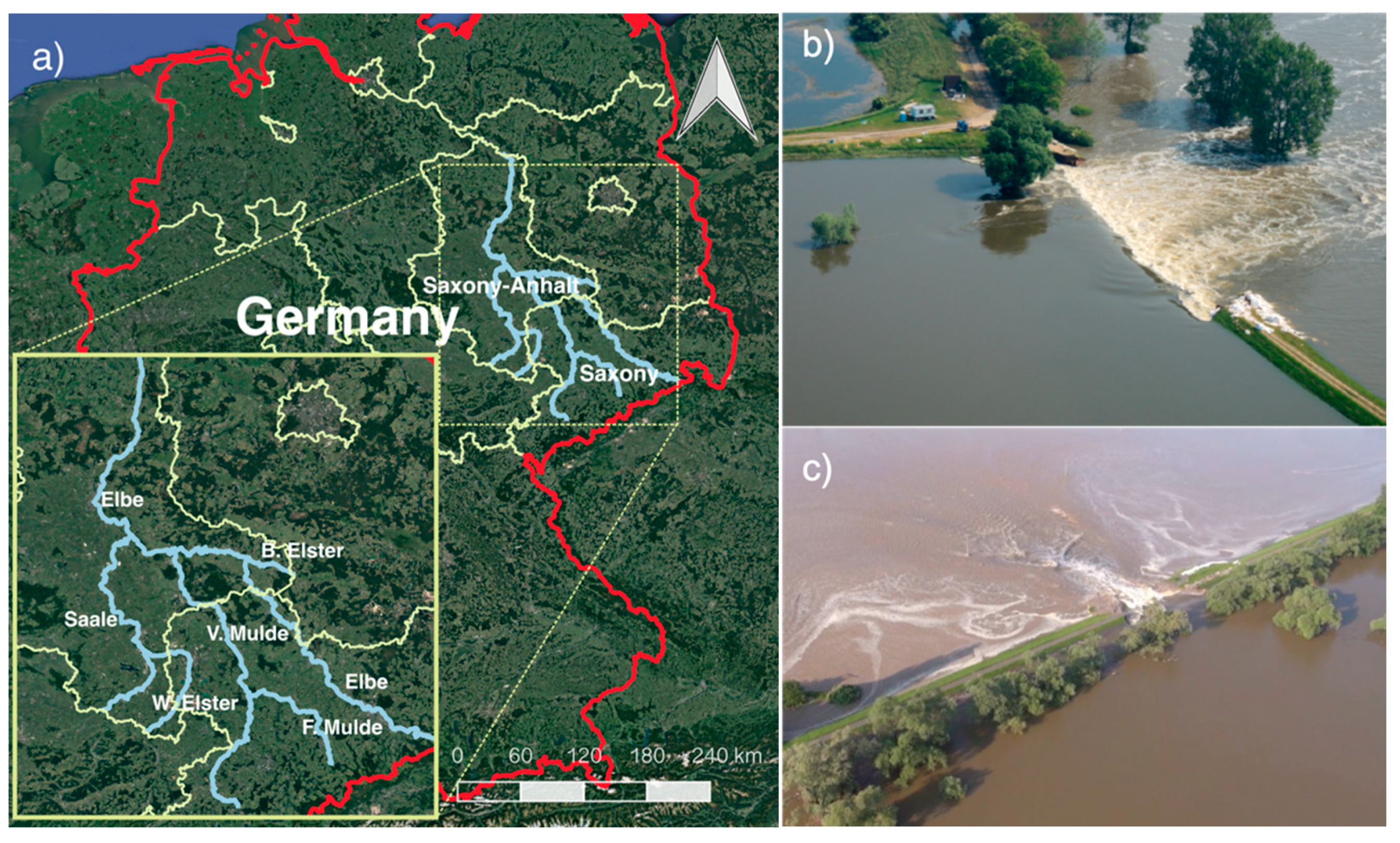
Further analysis of data from the ILPD at the event-level can provide insights in identifying (1) typical vulnerabilities and common failure mechanisms, (2) breach characteristics and (3) density of breach occurrence. Although events and levee systems are diverse, this information can be used to inform and improve (local) flood risk assessment. As an example, sub-dataset from the ILPD, information has been analysed on the performance of river levees along the Elbe tributaries in Germany, which flooded in 2002 and 2013 (Figure 8a). A general overview of the flood events is provided first, followed by a macro-scale analysis of the failures and the associated breaches.
3.2.1. Overview of the 2002 and 2013 Flood Events
The database reports on 111 levee failures along the Mulde and the Elbe rivers observed during the flooding event of August 2002, in Saxony and Saxony-Anhalt regions, Germany, as a result of extreme meteorological conditions, followed by extreme discharges and water levels [39]. Floods occurred mainly due to overflow/overtopping and breaching of levees at many locations. Return periods of river discharges exceeded 500 years at some tributaries of the Elbe and the return period along the Elbe and Mulde varied between 100–300 years [23,40]. Considering that the design return periods for the flood defences in Germany is usually 100 years, the levees along the rivers were significantly overloaded. Incomplete flood warnings, bad maintenance of flood defence structures and a lack of awareness were recognized as the weaknesses of the flood risk management [41]. The total damage was estimated around 11.6 billion euros which is the highest amount for a damage caused by a natural hazard in Germany.
Figure 8.
(a) Investigated rivers along the Elbe tributaries in Germany, which flooded in 2002 and 2013, (b) Fischbeck, 2013 (source: [42]), (c) Breitenhagen, 2013 (source: [43]).

Eleven years later, in June 2013, another big flood hit large parts of the same regions in Germany where multiple levee failures occurred. ILPD includes data from 17 cases of levee failures occurred in Saxony–Anhalt during this event (Figure 8a). Return periods of discharges were estimated between 50–500 years depending on the location. In this flooding event, the most seen failure mechanism was instability. Contrary to 2002, water levels in 2013 were mostly close to the crests of the levees, hence only few overflow/overtopping cases have been observed. Due to the high peak discharge, two catastrophic levee failures occurred in the central part of the Elbe River, namely Breitenhagen and Fischbeck (Figure 8b,c). The first failure near Breitenhagen occurred due to instability of the landside slope which later resulted in a 150 m wide breach and inundated an area of 80 km2 [44]. Simultaneously, the second failure near Fischbeck initiated with large cracks followed by settlement of the landside slope, resulting in a 100 m wide breach within hours. The main failure type is recorded as instability induced by internal erosion.
Although both the 2002 and 2013 events were large scale floods with severe consequences in history, the main differences between the two were as follows. In June 2013, heavy precipitation (total 170.5 mm within 24 h) in combination with high soil moisture levels, which in nearly 40% of Germany were at the highest levels since 1962 [45,46], resulted in levee breaches and flooding mainly in the central Elbe, Mulde and Saale catchments. Instead in 2002, extraordinary precipitation (record breaking rainfall of total 312 mm within 24 h) was the main driven mechanism [41]. Although hydrological conditions and flood levels were more severe compared to the 2002 event, the cost of damage in 2013 was much lower (6–8 billion euros) and fewer levee failures occurred. This was most likely the result of more effective flood management after the 2002 event, in particular more effective disaster management and improvements in maintenance of flood defences [41].
3.2.2. Analysis of the Failures
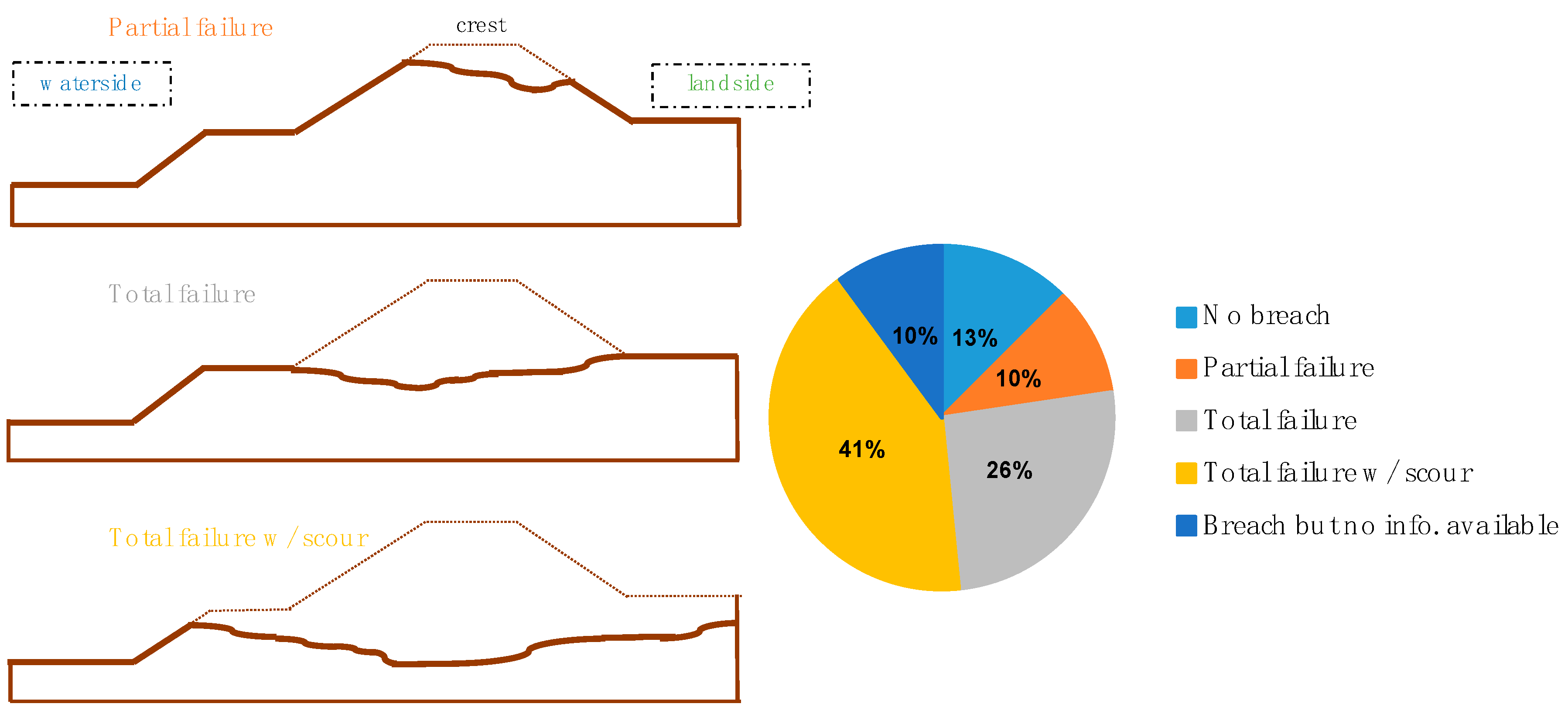
After these events, data was collected on levee failure cases, including location, geometry, levee structure, subsoil structure, vegetation, breach geometry and failure time. According to post-investigations [23,47], different degrees of damage have been observed on the levees. Based on the change in levee cross section, the breaches occurred in 2002 and 2013 are classified into three groups (Figure 9) as (a) partial failure (10%), where the breach depth was less than the crest height; (b) total failure (26%), when the crest was completely washed away; and (c) total failure with scour (41%), when, in addition to the crest, the soil beneath the toe level was also eroded. In most of the cases, the causes of levee failures were attributed to a combination of loads and local conditions (e.g., old breaches, tree roots, poor maintenance) [23].
An overview of the main failure mechanisms is given in Table 2. In 2002, there were more external erosion due to the overtopping/overflow cases, whereas in 2013, internal erosion and instability of the landside slope were the most common failure mechanisms.
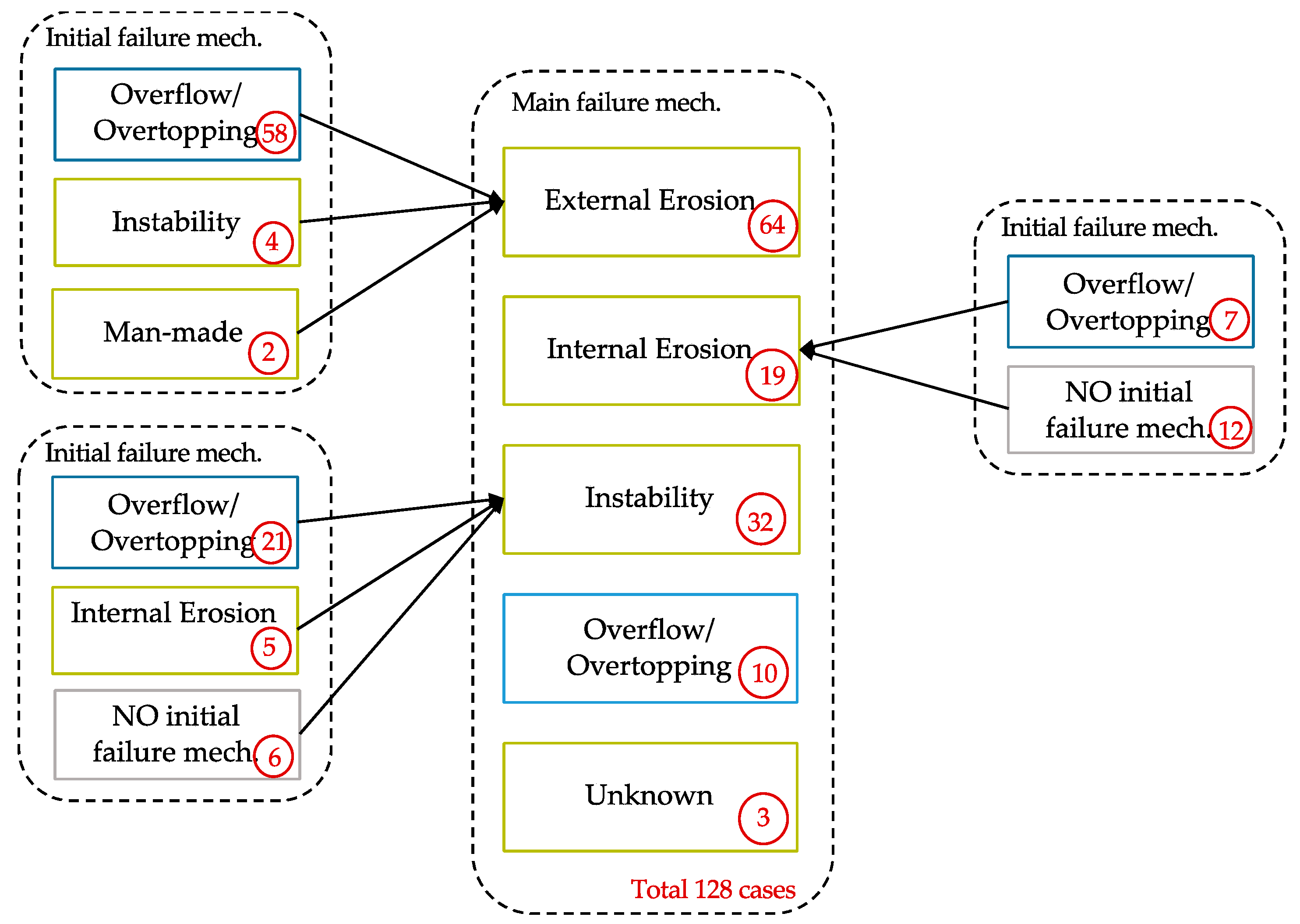
During the progress of these failures, multiple failure mechanisms were observed. In Figure 10, the occurrences of the different main failure mechanisms are associated with the initial mechanisms that have triggered them. Failure initiation mechanisms were mostly overtopping which was later followed by external erosion (58 cases), instability (21 cases) and internal erosion (7 cases). At some locations, overflow/overtopping (10 cases) occurred but did not lead to a levee breach. For example, four different levee breaches during the 2002 event have initiated with an instability of the landside slope which slipped away partially and the remaining part continued to be eroded gradually by overflowing water (external erosion).
3.3. Levee Breach Analysis
Although various breach prediction models have been developed empirically [48,49,50] and physically [51,52,53], there is still limited insight in the characteristics of breaches during real events. In this section, it is demonstrated for the Elbe case how information from the ILPD can be used to analyse breach dimensions, including the relationship with the failure mechanisms. Another important knowledge gap concerns the number of breaches and their width (i.e., breach density) which can be expected during flood events.
3.3.1. Analysis of the Failures
Data collected on the 128 levee failures that occurred during these two flooding events have been used to analyse the breach parameters. Table 3 shows the total breach width and the average breach width per failure for each damage type, classified according to Figure 9. If the damage to the crest increases (from partial failure to total failure with scour), the average breach width per failure becomes also larger. Although width and depth of levee breaches are not necessarily linearly correlated (Figure 7c), this analysis shows that when the breach is deep, then it is more likely to be wide as well. This is also in line with some breach growth models (e.g., [26]) which predict a lateral and vertical erosion in the later stages of the breaching process.
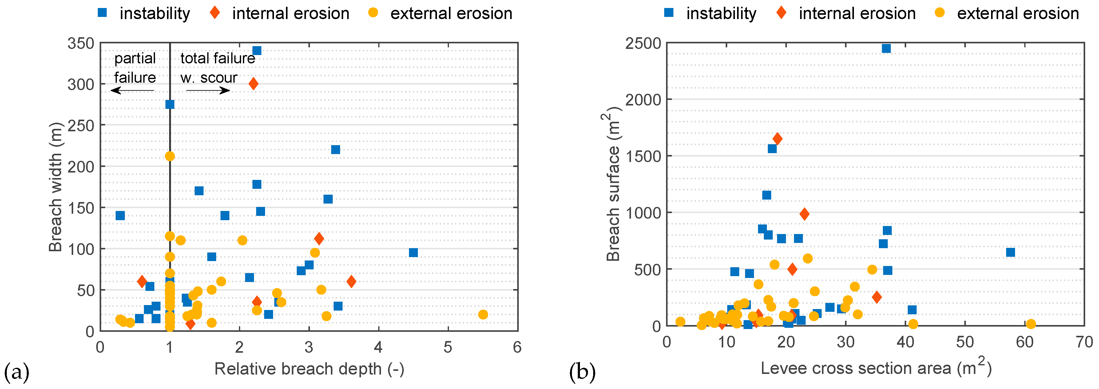
In order to further analyse the breach characteristics of the failures, the relation between breach parameters and failure mechanisms is assessed. First, the ratios between breach depth and crest level (i.e., relative breach depth) are compared with the breach width per main failure mechanisms (Figure 11a). It can be observed that, by normalizing the breach depth (as breach depth/crest level), the breach width is also larger for the failures with total scour. Moreover, the main failure mechanisms of most of the large breaches are observed as instability or internal erosion. Second, a comparison between breach surface (as breach depth × breach width) and geometry of the levees (i.e., cross section area) is given in Figure 11b per failure mechanisms. The levee surface could affect the breaching in different ways. A larger levee is associated with a larger hydraulic head (more forcing) but would also require more erosion during breaching (more resistance). Figure 11b shows that levees with large cross sections tend to have larger breach surfaces. Furthermore, the failures with large breaches (>500 m2) are due to instability, with only a few failures caused by internal erosion. Variations in breach surface for similar levee geometry might be explained by the differences in hydraulic head conditions. Moreover, recent studies show that even if the hydraulic load is the same, the duration of the load is also an important parameter in development of breach surfaces [54].
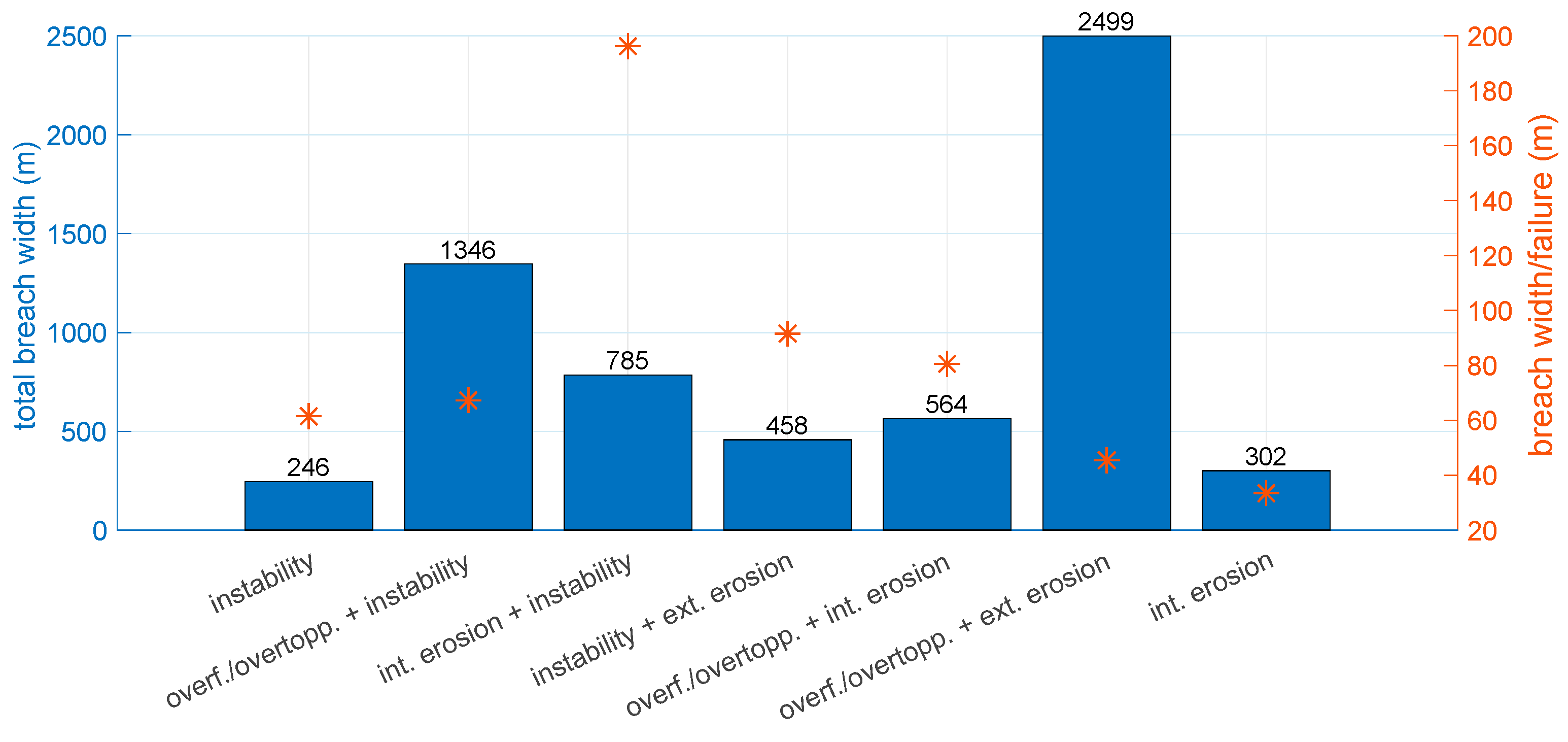
The understanding of failure patterns could be further deepened by checking how the failure initiated. Thus, the following analysis of the levee failures considers both their initial and main mechanisms. In Figure 12, the total and average breach width per failure mechanisms are compared. For instance, it can be seen that, if an external erosion case is initiated by instability, it is more likely to have a wider breach per failure than for an external erosion case that is triggered by overflow/overtopping. This can be explained as follows. When an instability occurs, most of the times a relatively large part of the crest is pushed away by internal forces with the following sequence of external erosion making the damage larger. Whereas, if the failure starts with overflow/overtopping which by time erodes the crest externally (external erosion), the levee is most likely to have smaller damages compared to the previous case. Another interesting observation is that some types of failure occur more often (e.g., external erosion triggered by overflow/overtopping) but with a relatively smaller average breach width per failure (i.e., smaller damage).
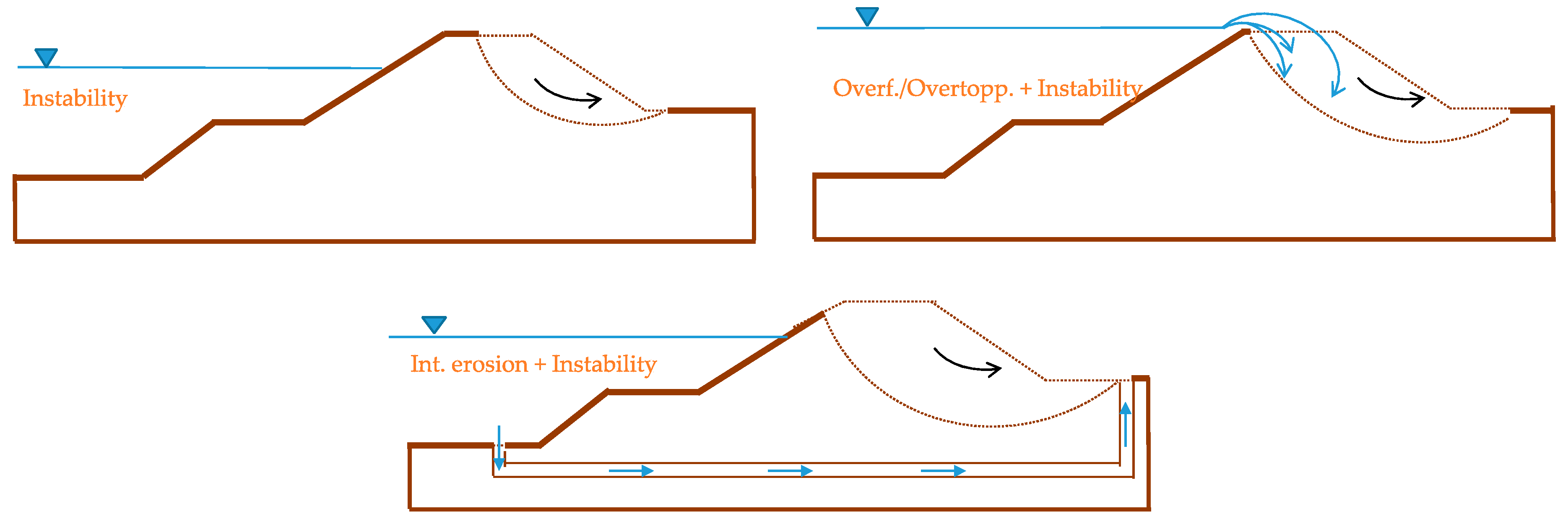
It is also noticed in Figure 12 that when an instability failure mechanism is initiated by internal erosion (e.g., piping), it is more likely to have wider breaches, whereas if it is initiated by overflow/overtopping, the size of the breach is smaller than the previous case but still larger than an instability failure without any initial mechanism. Figure 13 gives a schematization of these three cases. This trend can be explained by the fact that internal erosion, occurring directly in the subsoil, creates an extra hydraulic pressure below the crest. By time, the piping disconnects the upper part of the levee from its foundation, undermining the stability of a large section of the levee. In general, this analysis shows that the underlying failure mechanisms are of importance in the breach development.
3.3.2. Breach Density Analysis
One of the important aspects to consider in flood risk assessments is the levee breach density, which is related to the expected amount of levee breaches and their width. Risk assessments often assume that a breach can occur at random locations and often focus on a single breach and/or consider multiple breaches less likely [55]. However, actual flood events often comprise of multiple failures and breaches. Thus, it would be beneficial to estimate the expected breach density in order to complement the risk assessment of levees. Previously, a study [56] had addressed the distance between breaches as a function of overtopping rate for the two coastal levees failed during the events of New Orleans 2005 and Denmark 1976. However, related analyses have not been performed for river flood events yet.
In order to analyse the breach density, we first define two parameters, namely Failure intensity (km−1) and Breach width ratio (-), given in Equations (1) and (2) below,
where total breach width and river length are expressed in km. Failure intensity represents the occurrence of failure cases along the investigated river normalized by its length, whereas the breach width ratio corresponds to the ratio (in percentage) between the sum of all registered breach widths and the river length.
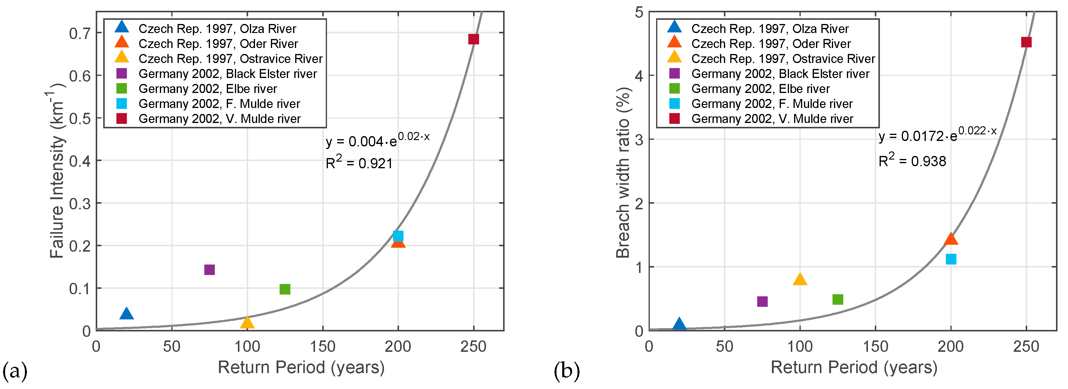
We analyse these parameters and compare with the return periods of discharge per each river for three flood events with multiple failures occurred in Germany in 2002 and 2013 (discussed previously) and also in Czech Republic in 1997, which are all stored in ILPD. The Czech event, also known in history as “The Great Flood of 1997”, mainly affected the Oder and Morava basins with multiple levee failures, of which 27 have been recorded in the ILPD. For both countries the river levees were supposed to be designed for events with return periods of 100 years [57].
The calculated parameters for the 1997 and 2002 events range between 0.02 and 0.68 km−1 for the failure intensity and between 0.08% and 4.5% for the breach width ratio, as shown in Figure 14. For the 2013 event, the values of the calculated breach width ratio (between 0.1%–0.4%) and failure intensity (between 0.03–0.1 km−1) are smaller than for the 2002 event, which can be explained by the strengthening of the levees after 2002, as explained in Section 3.2. However, although the conditions during the 2013 event was more severe, return periods found in the literature were either assessed with smaller values than for the 2002 event [58] or defined too general, that is “>100 years” [59,60]. Thus, the values for the 2013 event were not included in the rest of the analysis.
Considering the events of Germany 2002 and Czech Republic, it is noticed that when the return period () increases, the failure intensity and the breach width ratio also increase. For the seven rivers considered, a non-linear regression analysis using an exponential fitting function has been performed on the available data for both breach density parameters (trust-region optimization algorithm available in the MATLAB fit function). The resulting functional relations and the corresponding R2 values are given in Table 4. For instance, considering a river stretch of 50 km with a 125-year event, one would expect approximately five failures with a total width of 300 m according to these relations. Whereas, a 250-year event would lead to 22 failures with a total width of 1700 m for the same stretch. The functional relations given below are obtained from a limited amount of data. If more information regarding cases from different events will become available in the future, it can be used to validate the relations found and to refine the analysis.
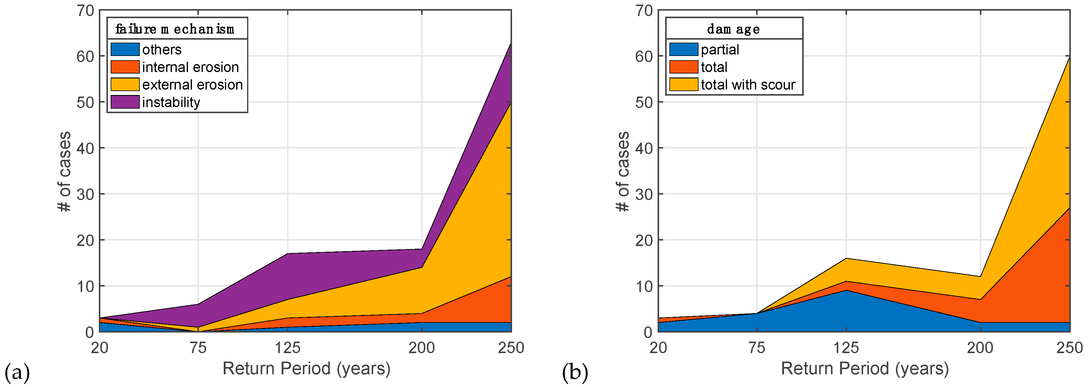
For the same events investigated above, we also explore the occurrences of different failure mechanisms and the degree of damage for different return periods (Figure 15a). In general, the total number of failures increases with the change in the return period. However, as it is given the Figure, external erosion is more likely to occur for high return periods. This can be explained by the fact that a high return period is related to high water levels and river discharges, which in turn leads to overtopping/overflow followed by an external erosion. Moreover, it is shown in Figure 15b that higher return periods lead to larger degrees of damage on the levees.
4. Discussion
4.1. ILPD
The ILPD is expected to become a global platform and scientific tool for various purposes, such as to advance the understanding of failure mechanisms and breaching of flood defences and to improve model development and validation. The first available version of the ILPD presented in this paper provides good coverage of some regions, for example, the Netherlands for the 20th century and it is already being used to support detailed studies, such as (1) geotechnical analysis of individual failures [44] and (2) detailed breach analysis [61]. In all other cases with only generic data, entries could still serve as a starting point for researchers to collect more detailed information. It is foreseen that the future expansion of the database will further offer valuable information to the scientific community as well as to the public and private sectors. More extensive datasets will give new insights into the field of flood risk and will stimulate the development and validation of more accurate techniques and modelling tools. This could eventually contribute to improving design methods of flood defences and to supporting risk assessments related to levee safety.
However, some operational obstacles must be overcome in order for the ILPD to become broadly applicable and representative. One of the main obstacles that we encountered is the issue of data sharing. It is believed that most of the detailed information is kept as an internal source since making the data public is a sensitive matter in many cases. A possible reason is that levee authorities and governments in many countries prefer not to advertise events whereby their levees failed. For instance, countries with few reported failure cases (e.g., China, Italy) in Figure 4 are not necessarily safer than the others (e.g., the Netherlands or Hungary) since many failures are known through media or registered information (e.g., EU documentation). This in fact highlights the importance of being transparent about data sharing and collaborations.
Another difficulty that arises while obtaining data is the language barrier. Across the world, detailed reports of flood events are obviously written in the official language of the country (e.g., Japanese). Especially when it concerns large quantities of data, extracting information from these reports for the ILPD becomes challenging. A way to potentially counteract this issue would be, for example, to request experts of international committees (e.g., ICOLD) to enter data related to their country into the database. However, this poses a new challenge, namely a higher demand on maintaining the database and providing support. Although there are some standard and ILPD-specific definitions for failure mechanisms and other parameters, people tend to use their own terminology, thus generating inconsistencies between cases. This is the reason why only the project members are currently allowed to enter data in the website. Thus, improving the ILPD towards a global, uniform database would require very systematic and intense data collection, also with the involvement and commitment of local stakeholders and levee managers.
4.2. Using Event-Level Analysis for Risk Assessments
Even though flood events and defence systems have specific characteristics and conditions, insights from the macro-scale analysis of the historical failures can be used to complement the (local) flood risk assessments. Firstly, the analysis of actual events could serve as calibration or reference for risk evaluations by highlighting dominant failure mechanisms and breach characteristics. For instance, as concluded in this study for the Elbe region, although some mechanisms occur more often, the damage that they cause on the levee can be less compared to the ones that has less occurrence. Likewise, it has been shown that it is important to consider not only the final failure mechanism that cause a breach but also the underlying processes that initiate the failure. These observations can be used by the local authorities as a starting point in assessing specific situations.
Another point is that current risk assessments generally tend to pay limited attention to failure scenarios with multiple breaches [55]. It is normally assumed in river levees that the occurrence of one breach reduces the expected likelihood of other breaches, as the inflow through the breach limits water levels downstream (i.e., retention effect). However, observations from the river floods studied here show that multiple breaches do occur during actual river floods, particularly when the system is overloaded by “design floods”. Thus, the observed breach densities and their identified relation with the return periods could be used, for instance in combination with fragility curves, to make more informed (simplified) risk assessments. Although in this study a general overview on the breach density parameters has been given, further research on this topic is recommended. A probabilistic analysis could be included by updating the failure probabilities at the failure locations based on the local information affecting the strength of the levee, such as vegetation type, old breaches, changes in soil profile.
5. Conclusions
In this paper, we introduced the International Levee Performance Database (ILPD), aiming to create a global information-sharing platform to facilitate research on levee performances. Besides, we conducted a macro-scale analysis of the currently available data. We outline common failure mechanisms of which external erosion of the slope is identified as the most frequent for levees and internal erosion for earthen dams. As an illustrative use of an ILPD sub-set, we examined breach characteristics of over a hundred failures during the flood events occurred in Germany (2002, 2013). Based on this analysis, we identified potential linkages between initial failure mechanisms, main failure mechanisms and the eventual breach characteristics. For instance, it is concluded that initial failure mechanisms play an important role in defining breach characteristics and that failures due to instability and internal erosion are less frequent but lead to a larger breach size. Based on events with multiple failures included in the database, we also identified a relation between the return period and the expected breach density during a flood event. Such relation can be improved and validated on cases from different events that will become available in the future.
The ILPD currently contains over 1500 entries covering historical failures, experiments and other performance observations. Even though we focused on the analysis of data at an event-level, ILPD sub-datasets can be used for more detailed analyses of individual failure processes, for instance, to investigate how occurrence of failure mechanisms is related to levee and loading characteristics or to analyse breach properties in more detail. Further research can also focus on combining information on levee failures from ILPD with information on historical flood levels and floodplain development [62]. Thus, the aim of the database for the future is to provide extensive and high-quality datasets to support the development and validation of accurate methods and models for failure mechanisms and breaching of flood defences. This is currently only restricted by the limited amount of data shared in the database, which is why a joint effort of the international scientific community, private companies and governments is required to make the ILPD complete and representative. The insights provided by the analysis of the historical flood events contained in the ILPD, in combination with hydraulic/geotechnical models, could eventually be used to complement risk assessments and to design more robust and resilient flood defences, with a smaller likelihood of catastrophic breaching.
Author Contributions
Conceptualization, I.E.Ö. and S.N.J.; methodology, I.E.Ö.; formal analysis, I.E.Ö.; data curation, I.E.Ö. and M.v.D.; writing—original draft preparation, I.E.Ö.; writing—review and editing, I.E.Ö., M.v.D. and S.N.J.; visualization, I.E.Ö.; supervision, M.v.D. and S.N.J. All authors have read and agreed to the published version of the manuscript.
Funding
This research was funded by Nederlandse Organisatie voor Wetenschappelijk Onderzoek (NWO TTW), grant number 13861.
Acknowledgments
We would like to thank to Torsten Heyer and Niklas Drews for providing data on the levee failures during Germany 2002 and 2013 flooding events; to Jozsef Danka for sharing his database; and to Wim Kanning for his valuable comments. Job Kool and Marijn de Rooij are also acknowledged for their contributions on the development of the ILPD.
Conflicts of Interest
The authors declare no conflict of interest.
References
- EEA. European Past Floods. Available online: https://www.eea.europa.eu/data-and-maps/data/european-past-floods/ (accessed on 29 October 2019).
- Özer, I.E.; van Leijen, F.J.; Jonkman, S.N.; Hanssen, R.F. Applicability of satellite radar imaging to monitor the conditions of levees. J. Flood Risk Manag. 2018. [Google Scholar] [CrossRef] [Green Version]
- Schweckendiek, T.; Vrouwenvelder, A.C.W.M.; Calle, E.O.F. Updating piping reliability with field performance observations. Struct. Saf. 2014, 47, 13–23. [Google Scholar] [CrossRef]
- Özer, I.E.; van Damme, M.; Schweckendiek, T.; Jonkman, S.N. On the importance of analyzing flood defense failures. In Proceedings of the Flood Risk 2016, 3rd European Conference on Flood Risk Management, Lyon, France, 17–21 October 2016. E3S Web of Conferences. [Google Scholar]
- NPDP. National Performance of Dams Program. Available online: http://npdp.stanford.edu/data_library (accessed on 1 November 2019).
- Fry, J.J.; Le Bourget du Lac, F.; Courivaud, J.R.; Blais, J.P. Dam Accident Data Base DADB–The Web Based Data Collection of ICOLD. In Proceedings of the 13th Conference on British Dam Society and the ICOLD European Club Meeting, Canterbury, UK, 22–26 June 2004. [Google Scholar]
- Froehlich, D.C. Embankment dam breach parameters. In Proceedings of the Hydraulic Engineering 1987 National Conference, Williamsburg, WA, USA, 3–7 August 1987. ASCE. [Google Scholar]
- Xu, Y. Analysis of Dam Failures and Diagnosis of Distresses for Dam Rehabilitation. Ph.D. Thesis, Hong Kong University of Science and Technology, Hong Kong, China, 2010. [Google Scholar]
- Peng, M.; Zhang, L.M. Breaching parameters of landslide dams. Landslides 2012, 9, 13–31. [Google Scholar] [CrossRef]
- Foster, M.; Fell, R.; Spannagle, M. The statistics of embankment dam failures and accidents. Can. Geotech. J. 2000, 37, 1000–1024. [Google Scholar] [CrossRef]
- Fry, J.J. Dam failures by erosion: Lessons from ERINOH database. In Proceedings of the 6th International Conference on Scour and Erosion (ICSE-6), Paris, France, 27–31 August 2012. Société Hydrotechnique De France. [Google Scholar]
- ASDSO. Lessons Learned from Dam Incidents and Failures. Available online: http://damfailures.org/ (accessed on 10 November 2019).
- McClelland, D.M.; Bowles, D.S. Estimating Life Loss for Dam Safety Risk Assessment, A Review and New Approach; Institute for Dam Safety Risk Management, Utah State University: Logan, UT, USA, 2002. [Google Scholar]
- USBR. Reclamation Consequence Estimating Methodology, Dam Failure and Flood Event Case History Compilation; Technical Report; U.S. Department of the Interior Bureau of Reclamation: Washington, DC, USA, 2015.
- CRED. The International Disaster Database (EM–DAT). Available online: https://www.emdat.be/ (accessed on 30 May 2019).
- DFO. Dartmouth Flood Observatory of Large Floods. Available online: http://floodobservatory.colorado.edu/Archives/index.html (accessed on 30 May 2019).
- Scussolini, P.; Aerts, J.C.; Jongman, B.; Bouwer, L.M.; Winsemius, H.C.; de Moel, H.; Ward, P.J. FLOPROS: An evolving global database of flood protection standards. Nat. Hazards Earth Syst. Sci. 2016, 16, 1049–1061. [Google Scholar] [CrossRef] [Green Version]
- DWR. DWR Levee Breach Database. Available online: http://www.dwr-lep.com (accessed on 30 May 2019).
- Barbetta, S.; Camici, S.; Maccioni, P.; Moramarco, T. National Levee Database: Monitoring, vulnerability assessment and management in Italy. In Proceedings of the EGU General Assembly, Vienna, Austria, 12–17 April 2015. [Google Scholar]
- USACE. National Levee Database. Available online: http://nld.usace.army.mil/ (accessed on 30 April 2019).
- Seed, R.B.; Bea, R.G.; Athanasopoulos-Zekkos, A.; Boutwell, G.P.; Bray, J.D.; Cheung, C.; Cobos-Roa, D.; Harder, L.F., Jr.; Moss, R.E.; Pestana, J.M.; et al. New Orleans and hurricane Katrina. III: The 17th street drainage canal. J. Geotech. Geoenviron. Eng. 2008, 134, 740–761. [Google Scholar]
- Seed, R.B.; Bea, R.G.; Athanasopoulos-Zekkos, A.; Boutwell, G.P.; Bray, J.D.; Cheung, C.; Cobos-Roa, D.; Ehrensing, L.; Harder, L.F., Jr.; Pestana, J.M.; et al. New Orleans and Hurricane Katrina. II: The central region and the lower Ninth Ward. J. Geotech. Geoenviron. Eng. 2008, 134, 718–739. [Google Scholar]
- Horlacher, H.B.; Heyer, T.; Carstensen, D.; Bielagk, U.; Bielitz, E.; Müller, U. Analysis of dyke breaks during the 2002 flood in Saxony/Germany. In Proceedings of the LARS 2007–Catchment and Lake Research, Arba Minch, Ethiopia, 7–11 May 2007. FWU Water Resources Publications. [Google Scholar]
- Van Baars, S.; van Kempen, I.M. The causes and mechanisms of historical dike failures in the Netherlands. e-Water J. 2009, 2009, 3–14. [Google Scholar]
- Danka, J. Dike Failure Mechanisms and Breaching Parameters. Ph.D. Thesis, Hong Kong University of Science and Technology, Hong Kong, China, 2015. [Google Scholar]
- Visser, P. Breach Growth in Sand-Dikes. Ph.D. Thesis, Delft University of Technology, Delft, The Netherlands, 1998. [Google Scholar]
- Sills, G.L.; Vroman, N.D.; Wahl, R.E.; Schwanz, N.T. Overview of New Orleans levee failures: Lessons learned and their impact on national levee design and assessment. J. Geotech. Geoenviron. 2008, 134, 556–565. [Google Scholar] [CrossRef] [Green Version]
- Vinet, F.; Lumbroso, D.; Defossez, S.; Boissier, L. A comparative analysis of the loss of life during two recent floods in France: The sea surge caused by the storm Xynthia and the flash flood in Var. Nat. Hazards 2012, 61, 1179–1201. [Google Scholar]
- Bisschop, F. Erosion of Sand at High Flow Velocities. Ph.D. Thesis, Delft University of Technology, Delft, The Netherlands, 2018. [Google Scholar]
- Jonkman, S.N.; van den Bos, J.P. Flood Defenses Lecture Notes CIE5314, 2nd ed.; Delft University of Technology: Delft, The Netherlands, 2017. [Google Scholar]
- Sharp, M.; Wallis, M.; Deniaud, F.; Hersch-Burdick, R.; Tourment, R.; Matheu, E.; Seda-Sanabria, Y.; Wersching, S.; Veylon, G.; Durand, E. The International Levee Handbook; CIRIA: London, UK, 2013. [Google Scholar]
- Kok, M.; Jongejan, R.; Nieuwjaar, M.; Tanczos, I. Grondslagen voor Hoogwaterbescherming; Ministerie van Infrastructuur en Milieu en het Expertise Netwerk Waterveiligheid: Delft, The Netherlands, 2016. (In Dutch) [Google Scholar]
- Kanning, W. The Weakest Link: Spatial Variability in the Piping Failure Mechanism of Dikes. Ph.D. Thesis, Delft University of Technology, Delft, The Netherlands, 2012. [Google Scholar]
- TAW. Water Retaining Soil Structures; Technical Report; Rijkswaterstraat—Technical Advisory Committee on Water Defenses: Utrecht, The Netherlands, 1999. [Google Scholar]
- Van Damme, M.; Ozer, I.E.; Kool, J.J. Guidance of the International Levee Performance Database (ILPD); Technical Report; Delft University of Technology: Delft, The Netherlands, 2019. [Google Scholar]
- Bridle, R. ICOLD Bulletin 164: Internal erosion of existing dams, levees and dikes and their foundations. In Proceedings of the Bulletin 164: International Comission on Large Dams, London, UK, 15 May 2014. [Google Scholar]
- Nagy, L. Estimating dike breach length from historical data. Period. Polytech. Civ. Eng. 2006, 50, 125–138. [Google Scholar]
- Morris, M.W. Breaching of Earth Embankments and Dams. Ph.D. Thesis, The Open University, Milton Keynes, UK, 2011. [Google Scholar]
- Horlacher, H.B.; Bielagk, U.; Heyer, T. Analyse der deichbrüche an der elbe und mulde während des hochwassers 2002 im bereich sachsen. Res. Rep. 2005, 9, 82. (In German) [Google Scholar]
- Thieken, A.H.; Müller, M.; Kreibich, H.; Merz, B. Flood damage and influencing factors: New insights from the August 2002 flood in Germany. Water res. 2005, 41. [Google Scholar] [CrossRef]
- Thieken, A.H.; Kienzler, S.; Kreibich, H.; Kuhlicke, C.; Kunz, M.; Mühr, B.; Müller, M.; Otto, A.; Petrow, T.; Pisi, S.; et al. Review of the flood risk management system in Germany after the major flood in 2013. Ecol. Soc. 2016, 21, 51. [Google Scholar]
- Jüpner, R.; Henning, B. Deichbruch fischbeck–zwei jahre danach. Wasser und Abfall 2015, 11, 16–20. [Google Scholar]
- Weichel, T. Failure of the Breitenhagen Levee 2013–Drone Film; Landesbetrieb füe Hochwasserschutz und Wasserwirtschaft Sachsen-Anhalt: Breitenhagen, Germany, 2013. [Google Scholar]
- Kool, J.J.; Kanning, W.; Heyer, T.; Jommi, C.; Jonkman, S.N. Forensic analysis of levee failures: The Breitenhagen case. Int. J. Geoeng. Case Hist. 2019, 5. [Google Scholar] [CrossRef]
- Für Gewässerkunde, B. Das Juni-Hochwasser des Jahres 2013 in Deutschland; BfG Bericht: Koblenz, Germany, 2013. [Google Scholar]
- Jüpner, R. Coping with extremes–experiences from event management during the recent Elbe flood disaster in 2013. J. Flood Risk Manag. 2018, 11, 15–21. [Google Scholar] [CrossRef] [Green Version]
- Gocht, M. Deichbrüche und Deichüberströmungen an Elbe und Mulde im August 2002; Technical Report; Ökonomische Beratung für Wasser und Umwelt, Water and Finance: Berlin, Germany, 2004. [Google Scholar]
- Wahl, T.L. Uncertainty of predictiona of embankment dam breach parameters. J. Hydraul. Eng. 2004, 130, 389–397. [Google Scholar] [CrossRef]
- Froehlich, D.C. Embankment dam breach parameters and their uncertainties. J. Hydraul. Eng. 2008, 134, 1708–1721. [Google Scholar]
- Kakinuma, T.; Shimizu, Y. Large scale experiment and numerical modeling of a riverine levee breach. J. Hydraul. Eng. 2014, 140. [Google Scholar] [CrossRef]
- Temple, D.M.; Hanson, G.J.; Neilsen, M.L.; Cook, K.R. Simplified breach analysis model for homogeneous embankments: Part 1, Background and model components. In Proceedings of the 25th Annual United States Society on Dams (USSD) Conference, Salt Lake City, UT, USA, 6–10 June 2005. [Google Scholar]
- Morris, M.W. Breach Initiation and Growth: Physical Processes (FLOODsite Report T06-08-11); Technical Report; HR Wallingford: Wallingford, UK, 2009. [Google Scholar]
- Michelazzo, G. Breaching of River Levees: Analytical Flow Modelling and Experimental Hydro-Morphodynamic Investigations. Ph.D. Thesis, University of Braunschweig, Braunschweig, Germany, 2014. [Google Scholar]
- Curran, A.; De Bruijn, K.M.; Kok, M. Influence of water level duration on dike breach triggering, focusing on system behaviour hazard analyses in lowland rivers. Georisk Assess. Manag. Risk Eng. Syst. Geohazards 2018, 1–15. [Google Scholar] [CrossRef]
- Jonkman, S.N.; Vrijling, J.K.; Kok, M. Flood risk assessment in the Netherlands: A case study for dike ring South Holland. Risk Anal. 2008, 28, 1357–1373. [Google Scholar] [CrossRef]
- Bernitt, L.; Lynett, P. Breaching of sea dikes. In Proceedings of the 32nd Conference on Coastal Engineering (ICCE No 32), Shanghai, China, 30 June–5 July 2010. [Google Scholar]
- Riha, J.; Pohl, R.; Escuder, I.; Martinez, F.J.; Laasonen, J.; Isomaki, E.; Tourment, R.; Maurin, J.; Mallet, T.; Deniaud, Y.; et al. European Levees and Flood Defenses, Inventory of Characteristics, Risks and Governance (EURCOLD LFD-WG Meeting 2016); Technical Report; ICOLD: Lyon, France, 2016. [Google Scholar]
- LHW. Bericht über das Hochwasser im Juni 2013 in Sachsen-Anhalt: Entstehung, Ablauf, Management und Statistische Einordnung; Technical Report; Landesbetrieb für Hochwasserschutz und Wasserwirtschaft Sachsen-Anhalt (LHW): Magdeburg, Germany, 2014. (In German) [Google Scholar]
- Schröter, K.; Kunz, M.; Elmer, F.; Mühr, B.; Merz, B. What made the June 2013 flood in Germany an exceptional event? A hydro-meteorological evaluation. Hydrol. Earth Syst. Sci. 2015, 19, 309–327. [Google Scholar] [CrossRef] [Green Version]
- Thieken, A.H.; Bessel, T.; Kienzler, S.; Kreibich, H.; Müller, M.; Pisi, S.; Schröter, K. The flood of June 2013 in Germany: How much do we know about its impacts. Nat. Hazards Earth Syst. Sci. 2016, 16, 1519–1540. [Google Scholar] [CrossRef] [Green Version]
- Van Damme, M. An analytical approach to predicting breach width and breach hydrographs. Nat. Hazards 2019. under review. [Google Scholar]
- Kilianova, H.; Pechanec, V.; Brus, J.; Kirchner, K.; Machar, I. Analysis of the development of land use in the Morava River floodplain, with special emphasis on the landscape matrix. Morav. Geogr. Rep. 2017, 25, 46–59. [Google Scholar] [CrossRef] [Green Version]
Figure 1.
A screenshot of the opening page of the ILPD (leveefailures.tudelft.nl).

Figure 2.
General levee cross section, showing the main elements of a levee included in the ILPD.

Figure 3.
An overview of most relevant levee failure mechanisms and their most common contributing factors [9,31].

Figure 4.
Statistics on the failures (a) per country, (b) per time period entered in ILPD.

Figure 5.
Statistics of the levee information (a) crest height, (b) crest width (m) per number of cases.
Figure 5.
Statistics of the levee information (a) crest height, (b) crest width (m) per number of cases.

Figure 6.
Statistics on (a) the observed failure mechanisms in ILPD (b) a comparison between earthen dams and levees for the most common failure mechanisms.
Figure 6.
Statistics on (a) the observed failure mechanisms in ILPD (b) a comparison between earthen dams and levees for the most common failure mechanisms.

Figure 7.
Statistics on (a) breach depth (450 cases), (b) breach width (785 cases) and (c) breach depth vs. width for (402 cases, Pearson coefficient, r = 0.164).
Figure 7.
Statistics on (a) breach depth (450 cases), (b) breach width (785 cases) and (c) breach depth vs. width for (402 cases, Pearson coefficient, r = 0.164).

Figure 9.
Damage degrees of the failed levees in Elbe region, Germany, 2002 and 2013 (adapted from [23]).
Figure 9.
Damage degrees of the failed levees in Elbe region, Germany, 2002 and 2013 (adapted from [23]).

Figure 10.
Initial and main failure mechanisms of the failed levees in the Elbe region, Germany, occurred in 2002 and 2013.
Figure 10.
Initial and main failure mechanisms of the failed levees in the Elbe region, Germany, occurred in 2002 and 2013.

Figure 11.
Relation between (a) relative breach depth and breach width per failure mechanism; (b) breach surface and geometry of the levees per failure mechanism.
Figure 11.
Relation between (a) relative breach depth and breach width per failure mechanism; (b) breach surface and geometry of the levees per failure mechanism.

Figure 12.
Breach width analysis per failure mechanism occurred during the flooding event in Germany, 2002 and 2013.
Figure 12.
Breach width analysis per failure mechanism occurred during the flooding event in Germany, 2002 and 2013.

Figure 13.
A schematization of an instability failure with three possible initiation mechanisms.

Figure 14.
(a) Failure intensity (km−1) and (b) Breach width ratio (-) along the rivers investigated during Germany, 2002 and Czech Republic, 1997 events.
Figure 14.
(a) Failure intensity (km−1) and (b) Breach width ratio (-) along the rivers investigated during Germany, 2002 and Czech Republic, 1997 events.

Figure 15.
Distribution of (a) failure mechanisms and (b) degree of damage for different return periods (T) along the rivers investigated during Germany, 2002 and Czech Republic, 1997 events.
Figure 15.
Distribution of (a) failure mechanisms and (b) degree of damage for different return periods (T) along the rivers investigated during Germany, 2002 and Czech Republic, 1997 events.

Table 2.
Overview of the main failure mechanisms for the 2002 and 2013 events.
| Main Failure Mechanisms | Number of Cases | ||
|---|---|---|---|
| 2002 Event | 2013 Event | Total | |
| External Erosion | 59 (53.2%) | 5 (29.4%) | 64 (50%) |
| Instability | 26 (23.4%) | 6 (35.3%) | 32 (25%) |
| Internal Erosion | 14 (12.6%) | 5 (29.4%) | 19 (14.8%) |
| Overflow/Overtopping | 9 (8.1%) | 1 (5.9%) | 10 (7.8%) |
| Unknown | 3 (2.7%) | 0 (0%) | 3 (2.4%) |
| Total | 111 | 17 | 128 |
Table 3.
Breach width analysis per damage type, Germany 2002 and 2013.
| Damage Type | Num. of Cases | Total Breach Width | Avg. Breach Width per Failure |
|---|---|---|---|
| Partial Failure | 14 | 466 m | 33 m |
| Total Failure | 33 | 1740 m | 53 m |
| Total Failure w/scour | 52 | 3901 m | 75 m |
Table 4.
Regression functions and R2-values for the breach density parameters and return periods.
| Breach Density Parameter | Regression Function | R2 Values |
|---|---|---|
| Failure intensity (km−1) | 0.921 | |
| Breach width ratio (-) | 0.938 |
© 2019 by the authors. Licensee MDPI, Basel, Switzerland. This article is an open access article distributed under the terms and conditions of the Creative Commons Attribution (CC BY) license (http://creativecommons.org/licenses/by/4.0/).
Share and Cite
MDPI and ACS Style
Özer, I.E.; van Damme, M.; Jonkman, S.N. Towards an International Levee Performance Database (ILPD) and Its Use for Macro-Scale Analysis of Levee Breaches and Failures. Water 2020, 12, 119. https://doi.org/10.3390/w12010119
AMA Style
Özer IE, van Damme M, Jonkman SN. Towards an International Levee Performance Database (ILPD) and Its Use for Macro-Scale Analysis of Levee Breaches and Failures. Water. 2020; 12(1):119. https://doi.org/10.3390/w12010119
Chicago/Turabian StyleÖzer, Işil Ece, Myron van Damme, and Sebastiaan N. Jonkman. 2020. "Towards an International Levee Performance Database (ILPD) and Its Use for Macro-Scale Analysis of Levee Breaches and Failures" Water 12, no. 1: 119. https://doi.org/10.3390/w12010119
Note that from the first issue of 2016, this journal uses article numbers instead of page numbers. See further details here.