
Norton Point Beach
Norton Point Beach is an important barrier beach between Katama Bay and the Atlantic Ocean. This is approximately 2.5 mile long beach and its width varies from 95 feet to approximately 300 feet. A couple years ago the barrier beach was breached by a big storm. Today a channell exists between the Katama Bay and the Atlantic Ocean.
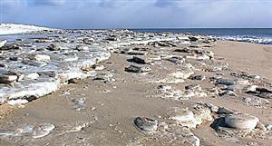
The photographs to the right were taken after the blizzard of January 23-24, 2005, whic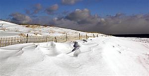 h dumped from 24 to 30 inches of snow on the island. The sand fencing in the first photograph is there to keep pedestrians out of the dunes in the warmer weather. But the drifts that accumulated to the near side of the sand fence were four feet deep. This storm left much larger drifts elsewhere on the beach and closed it to vehicular traffic for about two weeks. The lower photo shows the ice cakes and chunks of frozen sand that accumulate at the upper end of the wave wash on the ocean side of the beach.
Overall, Norton Point is losing an average of 10 feet per year, but this is a localized phenomenon. The eastern part of the beach has eroded significantly in the past five years. The large dunes (up to 16 feet above sealevel) that survived Hurricane Bob in 1991 and remained stable through the 1990s are now completely gone, and the beach that was 500 to 600 feet wide is now 200 to 300 feet wide. This erosion contrasts to the western half of the beach, which generally has re-established a wide beach between the dunes and ocean.
.jpg")