Grain Size and Pollen of Sediments in Wanghu Lake (Central China) Linked to Hydro-Environmental Changes

1
College of Earth Science and Engineering, Hohai Univ., Nanjing 210098, China
2
Key Laboratory of Hydrology and Water Resources and Hydraulic Engineering, Hohai University, Nanjing 210098, China
3
Nanjing Institute of Geography and Limnology, Chinese Academy of Sciences, Nanjing 210008, China
4
Editorial Department of Journal, Ningbo University, Ningbo 315211, China
*
Author to whom correspondence should be addressed.
Water 2020, 12(1), 45; https://doi.org/10.3390/w12010045
Submission received: 14 November 2019
/
Revised: 16 December 2019
/
Accepted: 18 December 2019
/
Published: 20 December 2019
(This article belongs to the Section Hydrology)
Abstract
:Grain size of lake sediments is often measured in paleolimnological studies, especially investigations of past paleoclimatic and paleohydrologic changes. The implications of such measures, however, remain unclear, since watershed hydrology and the related transfer of materials to the lake are affected by local climate variables, hydrological shifts, and vegetation cover variables. Sediment from Wanghu Lake in the middle reaches of the Yangtze River have apparently been affected by land cover changes and lake-river system transitions caused by a sluice gate built at Fuchi in 1967. These changes influenced the watershed hydrology, thereby confounding paleoclimatic and paleohydrologic interpretations by proxy records in sediment cores. We collected sediment cores from the center of Wanghu Lake and analyzed trends in pollen and physical properties through sedimentary records to investigate land cover changes and hydrological transitions during the past 90 years. The grain size of the sediment core increased with precipitation and the significant relationships between pollen and grain size after 1967 indicated that sediment transfer to the lake was controlled by rainfall and land cover changes due to human-induced deforestation and farming in the lake catchment. Interestingly before 1967, there was no significant relationship between the pollen and grain size or between the precipitation and grain size, indicating that the sediment of WanghuLake was not simply from the lake catchment. The different relationships patterns before and after 1967 indicated that the sediments in the lake were not only transported following precipitation and discharge from the lake catchment but also came from the Yangtze River draining back into the lake during the flood seasons before 1967. These results highlight matters needing attention and the potential application of grain size of sediments for reconstructions of past hydro-environmental changes.
1. Introduction
The lake-river systems associated with the Yangtze River are experiencing dramatic hydrological changes. This is partially due to human activities within the catchment, such as reservoir construction and land cover changes. Such transitions in hydrology impact river and floodplain ecology within the catchment [1]. However, the limited availability of pre-instrumental observations in the catchment undermines our ability to identify site-specific causes of the hydrological shifts [2]. Thus, alternative methods are required to identify the trends in and the main causes of historical change in the hydrology of lake-river systems.
Lacustrine sediments include information on high-resolution regional changes that can be used for reconstructing past hydroenvironmental changes and landscape processes in lake-catchment systems. Several such studies have already been conducted, in which the physical properties of the sediments, such as grain size and density, are used for proxies of hydrological factors and climatic factors [3,4,5,6,7]. For example, grain size and grain density are used for reconstructing past disastrous floods and typhoons [8,9]. D50 (median grain size), the diameter at the 50th percentile of the distribution curve, is particularly sensitive to hydrodynamic conditions. Higher D50 values represent coarser sediments in stronger hydrodynamic conditions [10,11]. Grain size also provides a good indicator of precipitation. Some research suggested an explanation that greater rainfall enhances soil erosion and increases the transport capacity of streams and rivers, leading to more and coarser clastic materials transported by rivers and subsequently deposited in the central part of the lake [12,13,14].
However, watershed hydrology and the related transfer of materials from terrestrial to aquatic systems are a function of several factors, including local climate variables, hydrological shifts, and vegetation cover variables [15]. For example, the removal of vegetation can increase water and material transfer to a lake [16,17,18,19]. Reliable paleoenvironmental reconstructions based on lacustrine sediment records therefore require an understanding of all the factors that affect catchment processes, including land cover changes and human disturbance [20,21,22,23,24,25]. However, the limited availability of information on historical changes in land cover undermines our ability to analyze catchment processes.
It is widely accepted that the majority of the pollen and spores entering larger lakes in sediments are fluvially transported from the lake catchments [26,27,28,29,30,31]. Flowering plant pollen and fern spores in sediment can be used to reconstruct land cover changes [32,33,34,35]. Therefore, they will enable us to analyze land cover changed in the catchment.
The aim of this study is to utilize a multiproxy approach to identify the historical hydrology of Wanghu Lake and investigate the impacts of lake system conversion from an overflowing lake to a closed basin and of land cover changes on the physical properties of the sediments based on determination of the pollen deposition sequence, grain size, and comparison with 90-year synchronous precipitation measurement.
2. Materials and Methods
2.1. Site Description
The Yangtze River ranks third globally in terms of length (6300 km), ninth in catchment area (1.8 × 10⁶ km2), fifth in water discharge (~900 km3 per year), and fourth in sediment flux. The middle Yangtze reaches are characterized by alluvial floodplains, which encompass a number of ecologically and economically valuable lakes and wetlands.Increasing human disturbances from rapid population growth and economic development in the catchment have caused environmental degradation of these lakes.
Wanghu Lake (29°51′–29°54′ N, 115°20′–115°25′ E) is located in Hubei Province, on the south bank of the middle reaches of the Yangtze River. It has a catchment area of 5310 km2 and a lake surface area of 42.3 km2. The lake has a mean depth of 3.7 m, a maximum recorded depth of 5.2 m, and lies at an altitude of 17 m.a.s.l. The subtropical monsoon climate in this region is characterized by warm and humid conditions. The mean annual air temperature is 15.9 °C, and the annual total precipitation is 1385 mm. The regional dominant vegetation around the lake is subtropical evergreen broad-leaved deciduous mixed forest and subtropical coniferous forests [36]. Yangxincounty, where Wanghu is located, has a complex soil parent material. The soil distribution shows obvious zonal difference. Soil parent material in the southwest and southeast of the county are mainly limestone and sand shale. The soil in the northwest is mainly black sand, red sand, and red loess, and the soil in the middle and northeast is multi tidal sand and tidal sand. The northwest is mostly granite and Quaternary red clay; the middle and northeast are mainly river lake alluvial sediments, red sandstone, and basalt.
The Fushui River, originating in the Mufu Mountains, drains into the lake and drains out to the Yangtze River at Fuchi (Figure 1). Wanghu Lake not only receives runoff from the catchment but also flood waters from the Yangtze River when the river exceeded bank-full capacity before 1967 [37]. A sluice gate was built at Fuchi in 1967, which has controlled the amount of lake water connected to the Yangtze River. As a consequence, river water from the upper and middle reaches of the Yangtze River now passes Wanghu.
2.2. Sampling
Four replicate sediment cores were collected in the center of the lake, where the water depth is about 4.2 m, using a gravity sampling system in November 2007 (29°51′49″N, 115°20′13″E) (Figure 1). These cores are referred to as WHA (42 cm), WHB (40 cm), WHC (36 cm), and WHD (50 cm). The four sediment cores are intact.The suspended layersof all the sediment cores are undisturbed. The longest core (WHD) was selected throughout this study. The core (WHD) were subsampled in the laboratory at 1 cm intervals and stored for further analysis at 4°C in the dark.
2.3. Precipitation Data in the Lake Catchment
Gauging recordsofprecipitation data from climate observation stations, Huangshi Station (1916–2000) in the lake catchment were used in this paper (National Climate Center of China, 2008). The record of 1938–1950 is missing.
2.4. Particle Size Analysis and Pollen Identification
Malvern Mastersizer 2000 (Malvern Instruments, Malvern, UK) was used to analyze the grain size of the 50 samples taken from the WHD core. Mastersizer 2000 was also used to calculate the statistical grain size parameters, including clay (<4 μm) and silt (4–63 μm) percentages, Dmean (mean grain size), and D50 (median grain size).
The 50 samples of pollen taken from the WHD core were processed using standard treatment methods of palynology, including CaCO3 removal using HCL, humic acid removal using NaOH, and finally silicate mineral removal using hydrofluoric acid [38]. The pollen concentration was traced and calculated by the known Lycopodiella density method. Pollen identification was determined according to “Pollen Flora of China” [39], “Angiosperm Pollen Flora of Tropic and Subtropic China” [40], and “Flora of Taiwan” [41].
2.5. Developing a Chronological Framework
Chronology calculations were based on 210Pb and 137Cs radioactive dating using an EG &GOrtec high purity germanium detector, and an ORTEC919 multichannel buffer-computer system. The multiple radionuclide values of the samples were measured using a γ-spectrum analysis system.
Because the appropriate choice of the calculation model is not known a priori, the CIC and CRS models were chosen to calculate chronologies and sedimentation rates [21,42]. The sediment dates were also calculated by piecewise linear function, based on 137Cs time mark, to compare with the results of 210Pb dates.
The CIC model assumes that sediments have a constant initial 210Pb concentration regardless of accumulation rate. The supply of 210Pb to lake sediment must vary directly in proportion to the sedimentation rate. Under such a scenario, the sediment age t at a depth x can be calculated using the formula:
where λ is the 210Pb radioactive decay constant (0.03114 yr−1), and C(x) and C(0) are the 210Pbex activity at a depth x and at the surface of the core, respectively [21,42].
The CRS model assumes that in these cases the flux of 210Pbex to the sediment surface remains constant regardless of any such variations [21,42]. This method relies on the ratio of the cumulative residual 210Pbex beneath a given depth to the total 210Pbex activity in the sediment column. It is therefore imperative that the entire 210Pb inventory of a core is measured or estimated as accurately as possible. The inventory is calculated as:
where C(m) is the mass specific 210Pbex concentration at mass depth m, and A(x) is the 210Pbex inventory beneath a given depth x. A(0) is the total 210Pbex activity in the sediment column [21,42]. The sediment age at a depth x can be calculated using the formula [21,42]:
2.6. Data Analysis
Changes in hydrology were inferred by identifying transitions in the pollen and physical properties of the sediments such as grain size. These transitions were determined by analyzing the changes in the relationship between the pollen and grain size in the WHD core before (26 samples: 50–24 cm) and after 1967 (23 samples: 23–0 cm).
Relations between grain size data and pollen data were explored using Pearson correlation analysis.
The scaled value grain size (D50) was compared to precipitation (1916–1937 and 1951–2000) from climate observation station Huangshi Station in the lake catchment. The scaling process is described:
where xD is the original value of D50 at a certain depth in the sediment core, xDmin is the minimum value of D50 through the core, xDmax is the maximum value of D50 through the core, and ZD50 is the scaled value of D50 at a certain depth in the core.
The scaling process was also applied to the precipitation data, described:
where xP is the original value of precipitation in a certain year, xPmin is the minimum value of precipitation, xPmax is the maximum value of precipitation, and ZPrecipitation is the scaled value of precipitation in a certain year.
3. Results
3.1. Precipitation Measurementin the Catchment
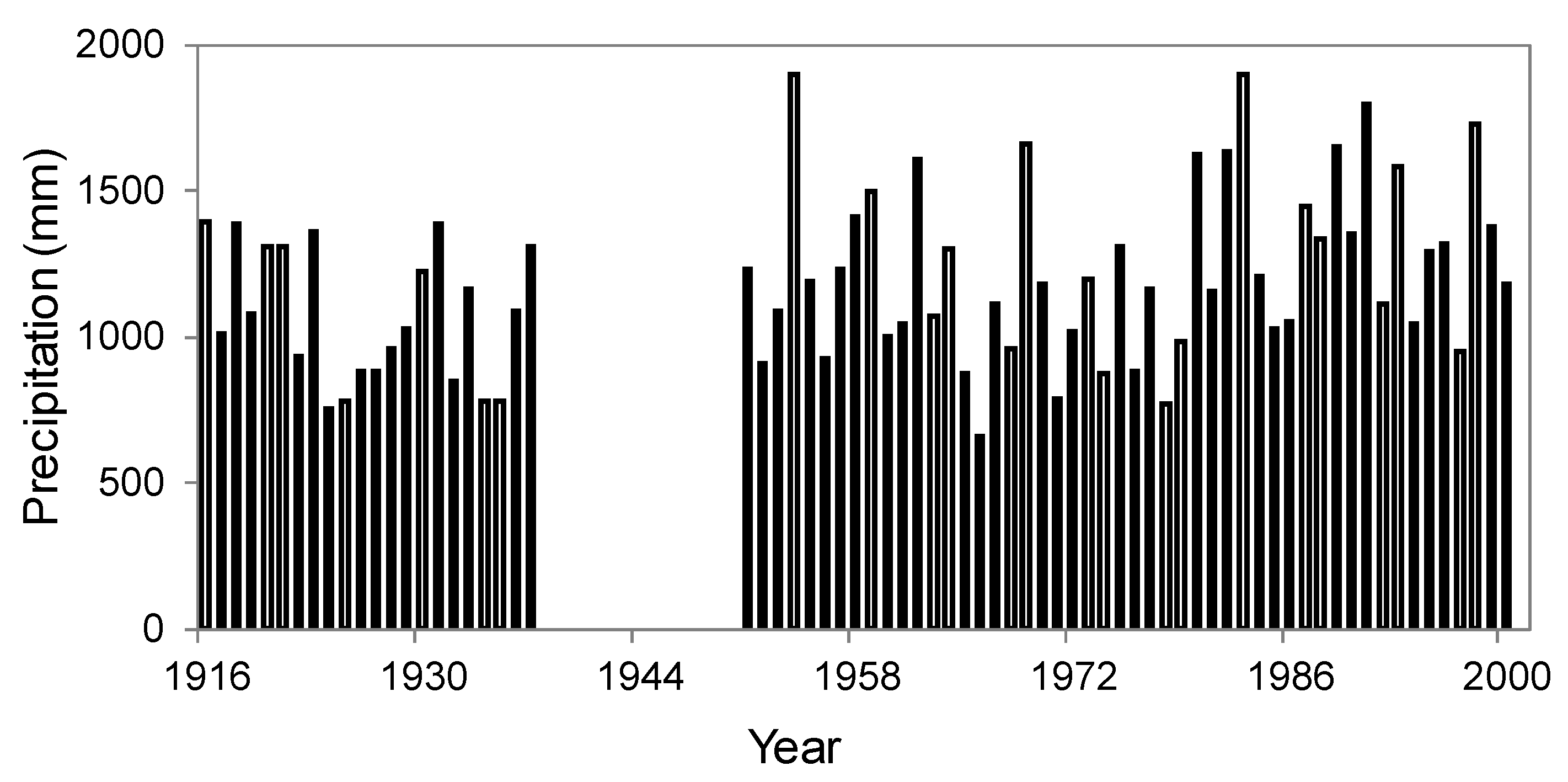
Figure 2 summarizes the time series of the precipitation data of Huangshistation from 1916–2000. The record of 1938–1950 is missing. The precipitation presents values between 661 mm and 1895 with mean values around 1184 mm. The whole time series display a high variability with no apparent trends. The low values in precipitation are observed before 1938 and 1965–1975.
3.2. Sediment Chronology
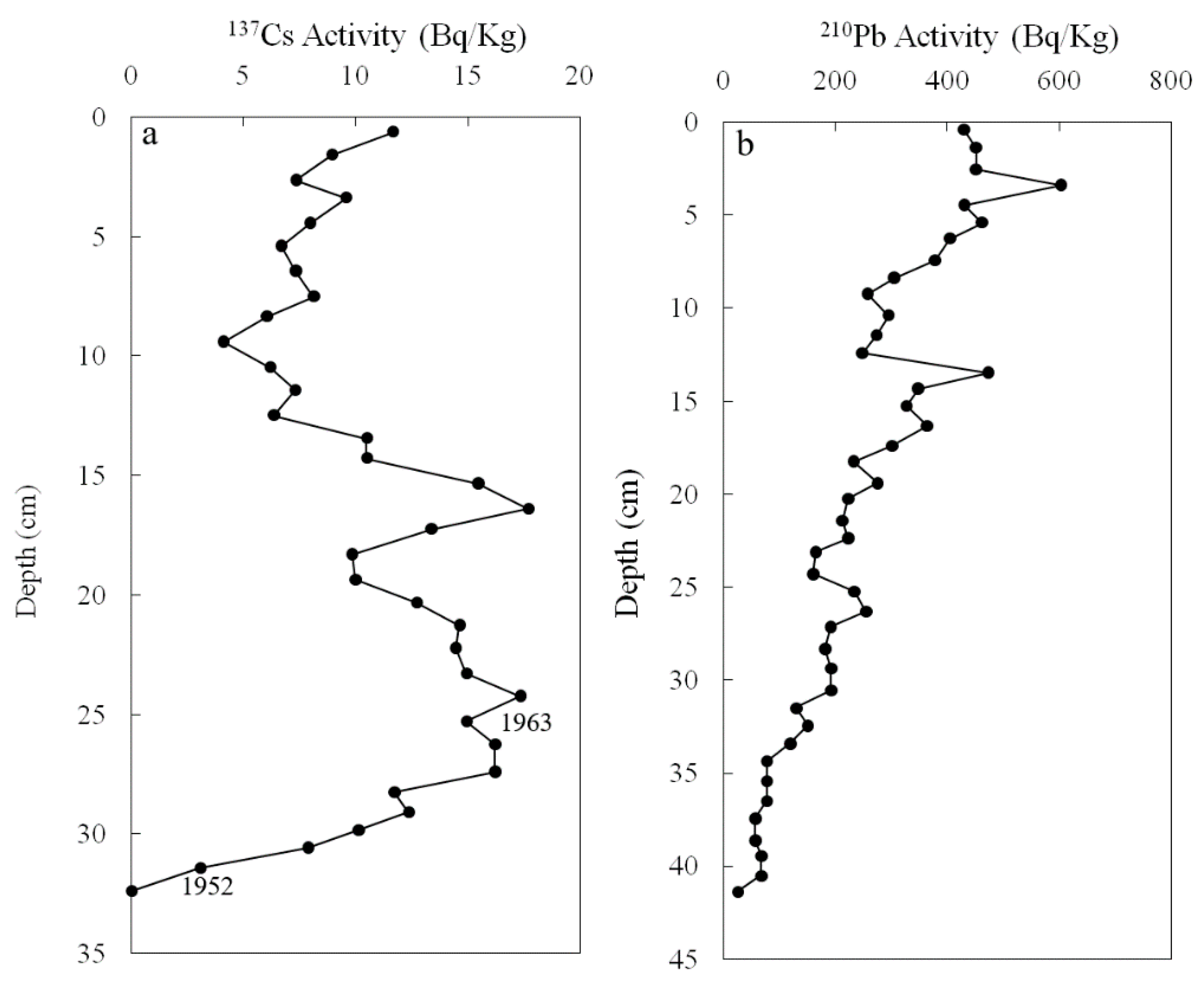
The specific activity of 137Cs in Wanghu Lake sediment cores varied with depth and showed two distinct peaks. The first peak (17.838 Bq/kg) appeared at a depth of 24.5 cm, and the secondary peak (17.816 Bq/kg) appeared at a depth of 16.5 cm. Furthermore, residues (2.644 Bq/kg) were observed at a depth of 31.5 cm. According to 137Cs profiles of lake sediments in the northern hemisphere, the zone of 137Cs where residues were observed corresponded to the global nuclear testing, which began in 1952; the first peak corresponded to the global 137Cs scattering peak that occurred in 1963. The signals of nuclear testing in the early 1970s and the 1986 Chernobyl accident can be captured in sediment cores of different regions in China. For example, the secondary137Cs peaks in sediment cores of Honghu Lake, Chaohu Lake, and Taihu Lake in the middle and lower reaches of the Yangtze River [43], Lugu Lake in Yunnan Province [44], and Bosten Lake in Xinjiang Province [45] are determined to be 1975. The other peak referred to the 1986 Chernobyl accident [46]. Therefore, the secondary peak is likely to have occurred in 1975 or 1986. As a precautionary measure, this paper used only 1952 and 1963 as reference points (Figure 3a,b).
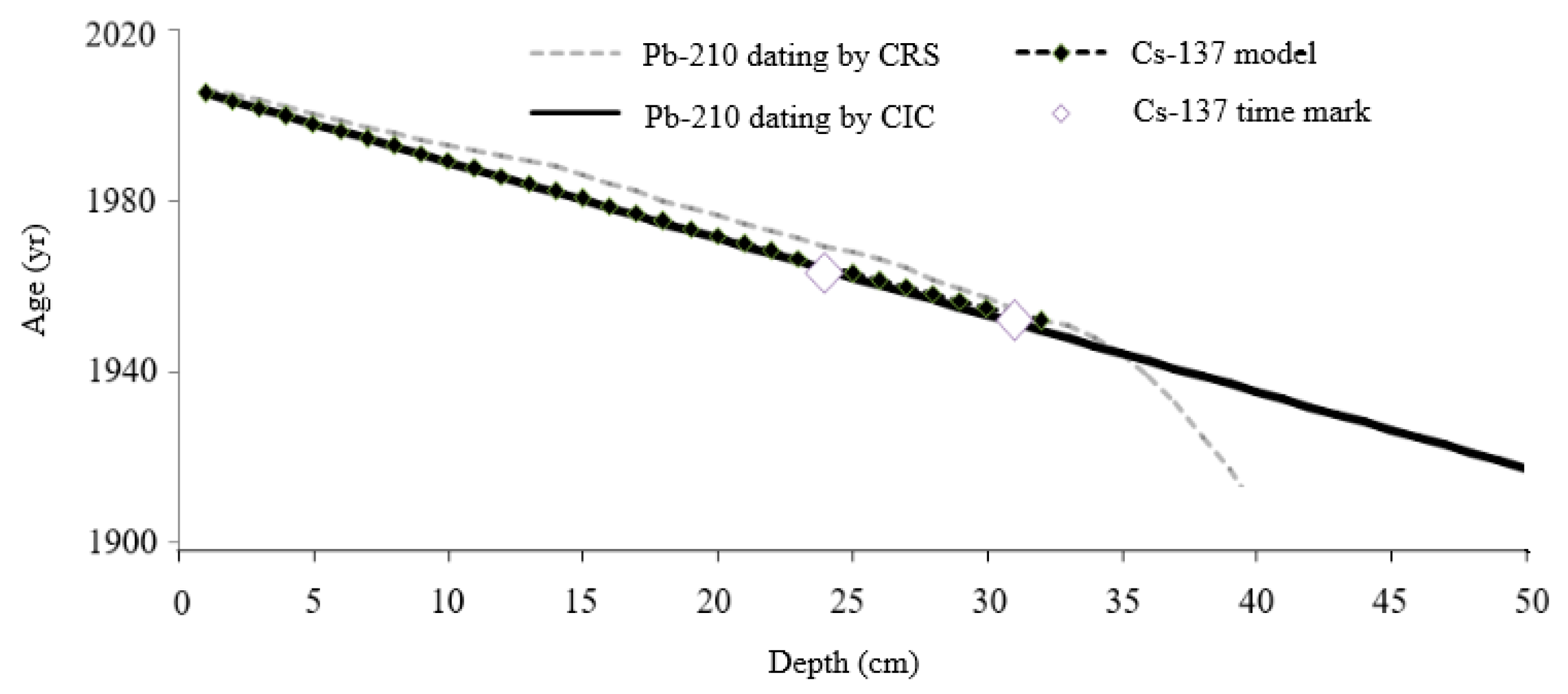
We applied the piecewise linear function based on 137Cs time mark, CIC, and CRS models to the WHD core.The age-depth resultsare shown in Figure 4. Generally, the 137Cs profile exhibited marked 1952 and 1963, which was in good agreement with the results of all the three models.Chronologies provided by all the three models showed a good fit in the upper strata (0–34 cm in the core: 2006–1944) of WHD core. The CRS model generally produced little younger ages (1–2 years) in upper sections of the core, while older ages in lower section (35–41 cm in the core). In this study we depict the results base on CIC model. The 50 cm core spans 90 years from 2006–1916, based on extrapolation of the CIC model.
3.3. The Wanghu Lake Sedment Core
3.3.1. Pollen Record
The stratigraphic distributions and relative abundance of pollen in the WHD core are shown in Figure 5. A total of 40,351 grains with 174 taxa of pollen and spores was counted in the WHD core. The average pollen concentration of each zone was 3287 grains/g. Major pollen types included trees (39 types), shrubs (44 types), upland herbs (68 types), aquatic herbs (6 types), and ferns (17 types). Moreover, 3096 grains of 2 taxa of fresh water algae were observed and counted. Pollen analysis of the core showed that the sum of tree and shrub pollen comprised 46–86% of the total count. The total herb pollen accounted for 6–29%, aquatic 1–25%, and ferns 4–23%.
The most abundant tree pollen was from deciduous oak trees (Quercus and Castanea) and evergreen oak trees (Cyclobalanopsis, Castanopsis, Lithocarpus and Fagus). Their percentages varied from 5% to 20% in the core samples. For herbaceous plants, the percentages of aquatic pollen were relatively high, reaching more than 20% in some layers and approximately 30% in total.
50–24 cm, 1916–1967: Tree and shrub pollen dominated this zone, with pine pollen accounting for 40–83%. The percentages of total herbs were 7–25%, aquatic 0–7% and ferns 10–23%. The average pollen concentration in this zone was 770–5500 grains/g. The sedimentation rates stay low and show an increasing tendency within the range of 0.1 cm/yr to 0.45 cm/yr.
23–0 cm, 1967–2006: Tree and shrub pollen decreased in this zone compared to that in zone 50–24 cm. The percentages of pine pollen were 33–63% in this zone. The percentages of total herb pollen showed significant increases. Fern pollen showed no significant changes. Aquatic and fresh water algae (Pediastrum) were found in abundance. The maximum pollen percentages of aquatic and freshwater algae (Pediastrum) were 26%, and the concentration was 2400 grains/g. The average pollen concentration in this zone increased to 2700–10,000 grains/g. The sedimentation rates increase compared to thelow section, especially after the 1980s.
3.3.2. Grain Size Analysis
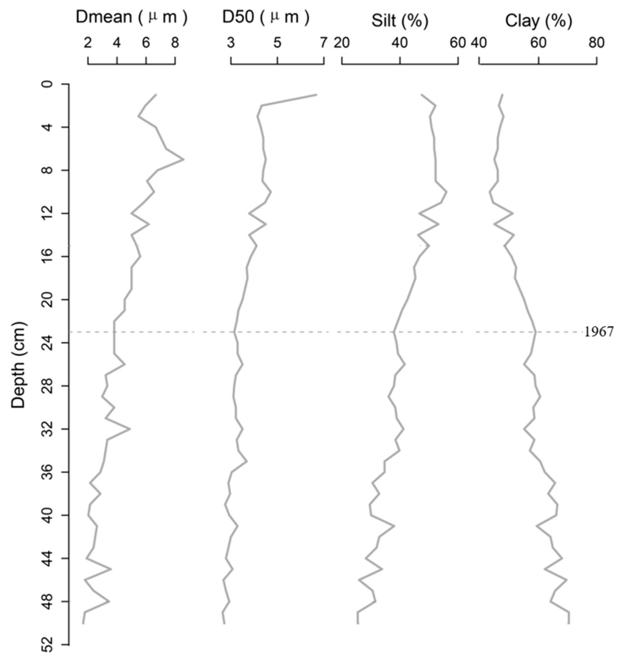
Clay (<4 μm) and silt (4–63 μm) percentage, Dmean and D50 from the WHD core are summarized in Figure 6.
50–24 cm, 1916–1967: The sediment is composed of gray clay. The clay percentage is relatively high and shows a moderating decreasing tendency with an average of 62%. The silt percentage, mean grain size (Dmean), and median grain size (D50) show a moderating increasing trend from 50 cm to 23 cm in depth, within the range from 25.02% to 41.85%, 1.67 μm to 4.88 μm, and 2.4 μm to 3.7 μm, with averages of 34.26%, 2.94 μm, and 3.08 μm, respectively.
23–0 cm, 1967–2006: The sediment is composed of gray silt with small snails and bioclasts. Compared to the sediment of 50–24 cm, the grain size increases sharply in this zone. The clay percentage shows a decreasing tendency within the range of 59 to 43% with an average of 50%. The silt percentage, Dmean and D50 show an increasing trend from the 23 cm to 0 cm depth, within the range from 37% to 56%, 3.2 μm to 8.6 μm, and 3.1 μm to 4.7 μm, with averages of 47%, 5.5 μm, and 3.9 μm, respectively.
3.3.3. Relationships between Pollen and Grain Size
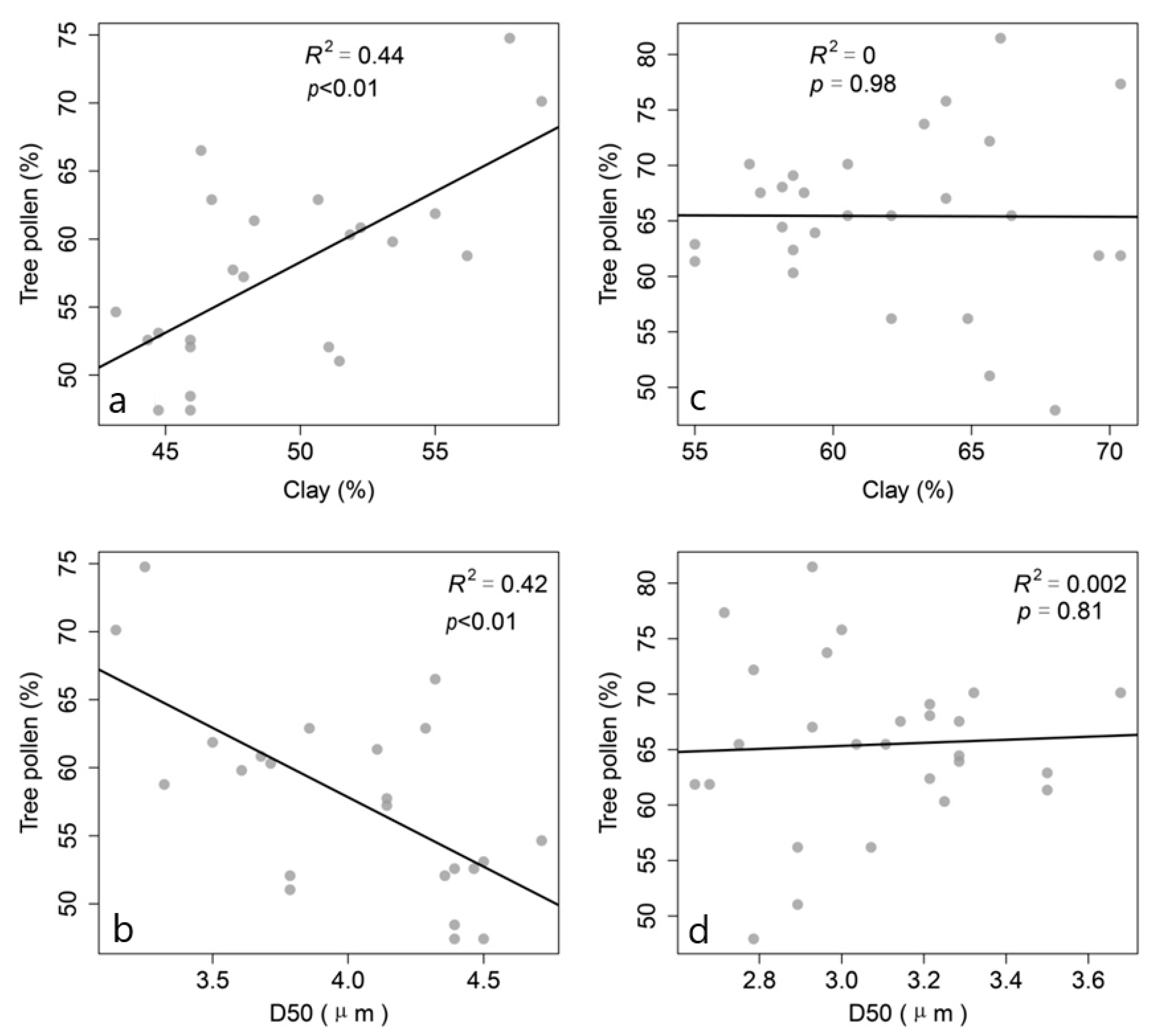
The tree pollen percentages have a significant positive correlation with clay percentages (R2 = 0.44, N = 23, p < 0.01) and significant negative correlation with D50 (R2 = 0.42, N = 23, p < 0.01) from depth 0–23 cm. However, the tree pollen percentages show no significant correlation with clay percentages (R2 = 0, N = 26, p = 0.98) and with D50 (R2 = 0.002, N = 26, p = 0.81) from 50–24 cm (Figure 7).
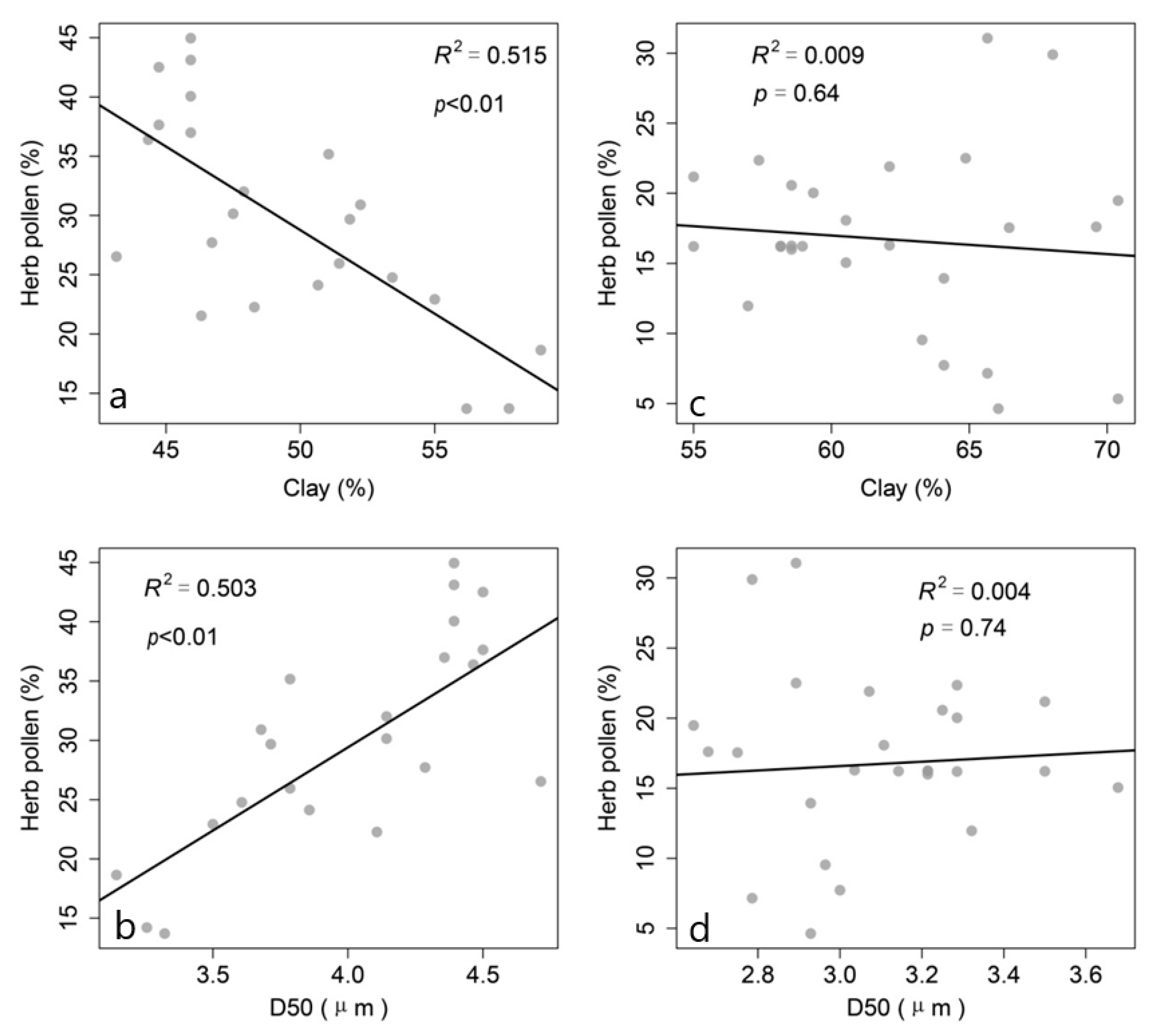
The herb pollen percentages have a significant negative correlation with clay percentages (R2 = 0.515, N = 23, p < 0.01) and significant positive correlation with D50 (R2 = 0.503, N = 23, p < 0.01) from depth 0–23 cm. However, herb pollen percentages show no significant correlation with clay percentages (R2 = 0.009, N = 26, p = 0.64) and with D50 (R2 = 0.004, N = 26, p = 0.74) from 50–24 cm (Figure 8).
3.3.4. Relationships between Precipitation and Grain Size
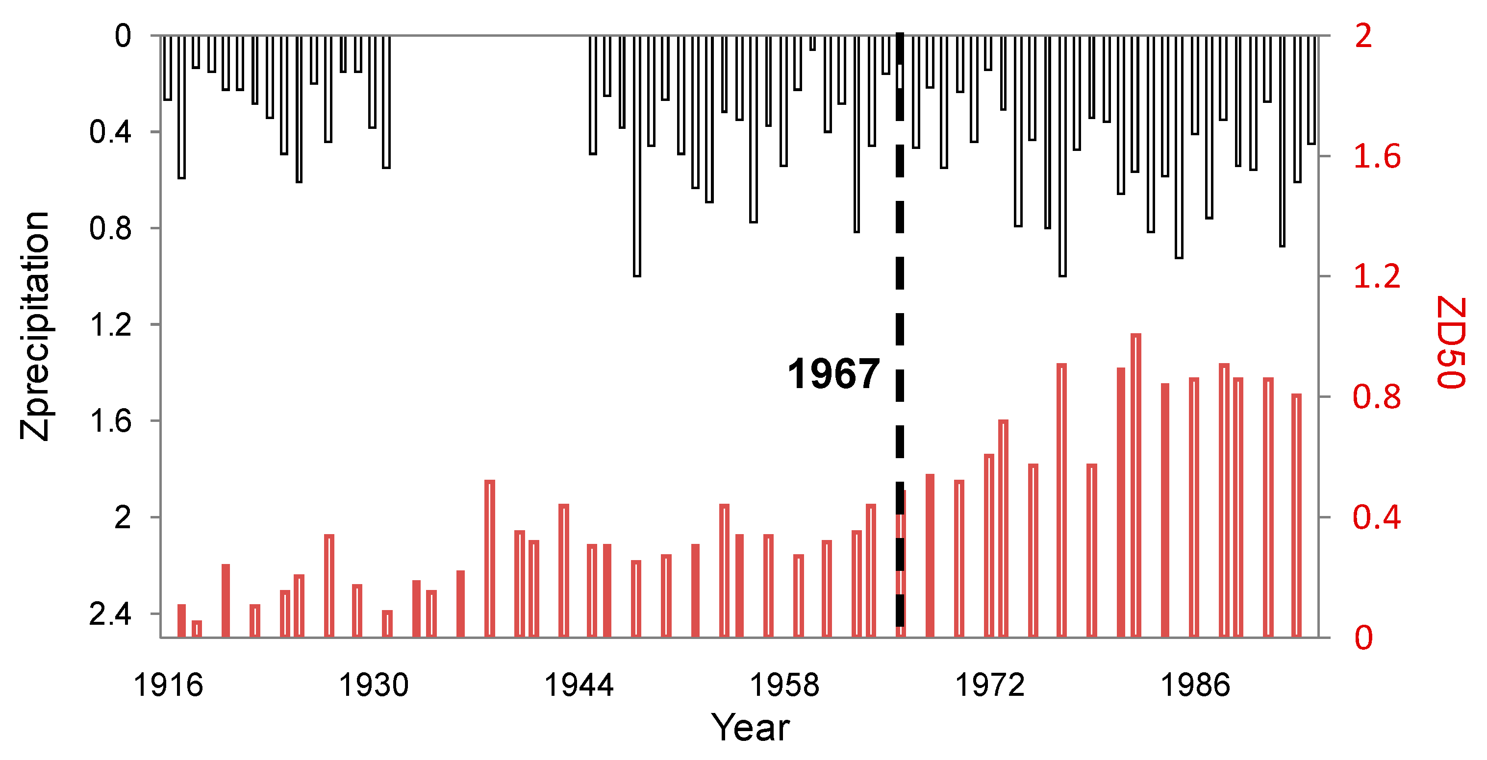
The D50 values from the WHD core are plotted against precipitation (Figure 9). No significant transition in the precipitation pattern was found during the past 90 years. After 1967, the D50 values changed with a similar trend of the precipitation. However, in the period 1916–1967, no such relationship was observed. The precipitation oscillates, but the D50 values remain stable in the period 1951–1965 and showed a moderating increasing tend during 1916 to 1951.
4. Discussion
4.1. Wanghu Lake and Watershed Evolution over the Last 90 Years
Before the 1960s, the watershed was in a natural state with negative population growth, and its economy was backward, according to Yangxin Country records [47]. Less reclamation and deforestation at a regional scale were marked by high pine pollen percentages and relatively low aquatic and total herb pollen percentages (Figure 5). The sediment core in this section was characterized by high clay percentages and fine grain size, indicating that the watershed remained relatively stable and less erodible (Figure 6). Under such a scenario, the average sedimentation rates were 0.18 cm/yr before the 1960s (Figure 5).
The tree pollen percentages showed decreasing tendency, and the upland herb pollen percentages increased, indicating that the lake and watershed were affected by human activities, especially demographic and economic development after 1980 (Editorial Board of Hubei Province, 1989–2010). Therefore, reclamation and deforestation accelerated surface soil erosion, subsequently increasing sediment loading into the lake [48]. Under such a scenario, the sedimentation rates sharply increased to 0.64 cm/yr after 1980 (Figure 5).
4.2. Sediment Cores as Archives of Historical Hydroclimatic Changes
Before 1967, Wanghu Lakes was hydrologically connected with the Yangtze River [47]. During this period, the average sedimentation rates remained relatively low (Figure 5). Previous studies found that the low sedimentation may be caused by frequent water exchange between the lakes and Yangtze River [48] becausesome of the sediments of the lakes were flushedinto the River and led to low sedimentation rates.
The sedimentation rates may also be caused by rain in the catchment [48,49,50,51,52,53]. Many researchers have shown that low sedimentation rate and a finer mean grain size reflects decreased amounts of rain in various settings [3,4,5,6,7,9]. However, in this case, the sedimentation rates and grain size did not change with rain in the catchment (Figure 5 and Figure 9) before 1967. We explained that the sedimentation rate and grain size are mainly affected by sediments from the Yangtze River. Yi et al. (2006) found that flood water particles that drained back into the lake connected to Yangtze River were mainly clay [8].
After 1967, a sluice gate was built at Fuchi, and as a consequence, river water from the upper and middle reaches of the Yangtze River passed Wanghu Lake. The lake became a closed lake deposition system with a more stable aquatic environment, as evidenced by the greater concentrations of aquatic plants (Figure 5). The average sedimentation rates increased sharply to 0.41 cm/yr during 1967–1980 and 0.64 cm/yr (Figure 5) after the 1980s.
Since the lake was not affected by Yangtze River, sedimentation rates and grain size may be caused by increasing precipitation (Figure 9) and intensive reclamation and deforestation in the catchment [3,4,5,6,7,9,47]. In this study, a similar D50 and precipitation trend could be found in Wanghu Lake after 1967 (Figure 9). Previous studies have shown that a coarser mean grain size reflects heavier and increased amounts of rainfall in various settings [3,4,5,6,7,9]. The significant relationships between the pollen and grain size after 1967 (Figure 7a,b and Figure 8a,b) indicated that sediment transfer to the lake was also controlled by land cover change caused by human-induced deforestation and farming.
5. Conclusions
Multiple 210Pb-based dating models were tested to establish a chronological framework for lake sediments in Wanghu Lake. Due to land reclamation, deforestation, and building of a sluice gate, sedimentation rates increased after the 1960sand reached a peak after the 1980s.The physical properties of lacustrine sediments are among the most convenient proxies for reconstructing past hydrological conditions. However, discrepancies among hydrological inferences based on records from lacustrine deposits can still occur since watershed hydrology and the related transfer of water and materials to lakes are a result of many factors [54,55,56,57,58]. The results from Wanghu Lakes suggest that natural or anthropogenic changes in vegetation cover and hydrological transitions within watersheds can alter sediment processes, thereby confounding paleoclimatic inferences based on grain size.
Author Contributions
H.S. designed the overall concept of the methodology, carried out the analysis, data collection and curation, and wrote the article; Z.Y. worked on the overall concept of the research, project administration; G.Y. was actively involved in the overall concept of the methodology, carried out the formal analysis, and wrote the article; X.S. contributed to the field work and grain size analysis. All of the authors contributed substantially to the work reported. All authors have read and agreed to the published version of the manuscript.
Funding
This work was jointly supported by the National Natural Science Foundation of China (Grant Nos. 41401092,41323001) and the Special Fund of State Key Laboratory of Hydrology-Water Resources and Hydraulic Engineering (Grant No. 20145027312).
Conflicts of Interest
The authors declare no conflict of interest.
References
- Nilsson, C.; Berggren, K. Alterations of Riparian ecosystems caused by river regulation. Bioscience 2000, 50, 783–792. [Google Scholar] [CrossRef]
- Benito, G.; Lang, M.; Barriendos, M.; Llasat, M.C.; Frances, F.; Ouarda, T.; Thorndycraft, V.R.; Enzel, Y.; Bardossy, A.; Coeur, D.; et al. Use of systematic, palaeoflood and historical data for the improvement of flood risk estimation. Review of scientific methods. Nat. Hazards 2004, 31, 623–643. [Google Scholar]
- Rodbell, D.T.; Seltzer, G.O.; Anderson, D.M.; Abbott, M.B.; Enfield, D.B.; Newman, J.H. An 15,000-year record of El Nino-driven alluviation in southwestern Ecuador. Science 1999, 283, 516–520. [Google Scholar] [CrossRef] [PubMed] [Green Version]
- Brown, S.; Bierman, P.; Lini, A.; Davis, P.T.; Southon, J. Reconstructing lake and drainage basin history using terrestrial sediment layers: Analysis of cores from a post-glacial lake in New England. J. Paleolimnol. 2002, 28, 219–236. [Google Scholar] [CrossRef]
- Noren, A.J.; Bierman, P.R.; Steig, E.J.; Lini, A.; Southon, J. Millennial-scale storminess variability in the northeastern United States during the Holocene epoch. Nature 2002, 419, 821–824. [Google Scholar] [CrossRef]
- Shimada, T.; Kashiwaya, K.; Hyodo, M.; Masuzawa, T. Hydro-environmental fluctuation in a lake-catchment system during the late Holocene inferred from Lake Yogo sediments. Trans. Jpn. Geomorphol. Union 2002, 23, 415–431. [Google Scholar]
- Nahm, W.H.; Lee, G.H.; Yang, D.Y.; Kim, J.Y.; Kashiwaya, K.; Yamamoto, M.; Sakaguchi, A. A 60-year record of rainfall from the sediments of Jinheung Pond, Jeongeup, Korea. J. Paleolimnol. 2010, 43, 489–498. [Google Scholar] [CrossRef]
- Yi, C.L.; Liu, H.F.; Neil, L.R.; Yang, H.; Ni, L.Y.; Xie, P. Sediment sources and the flood record from Wanghu lake, in the middle reaches of the Yangtze River. J. Hydrol. 2006, 329, 568–576. [Google Scholar] [CrossRef]
- Itono, T.; Kashiwaya, K.; Sakaguchi, A. Disastrous flood events found in lacustrine sediments from Lake Biwa. Trans. Jpn. Geomorphol. Union 2012, 33, 453–468. [Google Scholar]
- Sun, Q.L.; Zhou, J.; Xiao, J.L. Grain-size characteristics of Lake Daihai sediments and its paleaoenvironment significance. Mar. Geol. Quat. Geol. 2001, 21, 93–95, (In Chinese with English abstract). [Google Scholar]
- Liu, X.Q.; Wang, S.M.; Shen, J. The grainsize of the core QH2000 in Qinghai Lake and its implication for paleoclimate and paleoenvironment. J. Lake Sci. 2003, 15, 112–117, (In Chinese with English abstract). [Google Scholar]
- Kashiwaya, K.; Yamamoto, A.; Fukuyama, K. Time variations of erosional force and grain size in Pleistocene lake sediments. Quat. Res. 1987, 28, 61–68. [Google Scholar] [CrossRef]
- Peng, Y.J.; Xiao, J.L.; Nakamura, T.; Liu, B.L.; Inouchi, Y. Holocene East Asian monsoonal precipitation pattern revealed by grain-size distribution of core sediments of Daihai Lake in Inner Mongolia of north-central China. Earth Planet. Sci. Lett. 2005, 233, 467–479. [Google Scholar] [CrossRef]
- Jiang, Q.F.; Shen, J.; Liu, X.Q.; Ji, J.F. Environmental changes recorded by lake sediments from Lake Jili, Xinjiang during the past 2500 years. J. Lake Sci. 2010, 22, 119–126, (In Chinese with English abstract). [Google Scholar]
- Mason, I.M.; Guzkowska, M.A.J.; Rapley, C.G.; Street-Perrott, F.A. The response of lake levels and areas to climatic change. Clim. Chang. 1994, 27, 161–197. [Google Scholar] [CrossRef]
- Hibbert, A.R. Forest treatment effects on water yield. In Proceedings of the International Symposium of Forest Hydrauli, State College, PA, USA, 29 August–10 September 1965; Sopper, W.E., Lull, H.W., Eds.; Oxford: Pergamon, Turkey, 1967; pp. 527–543. [Google Scholar]
- Bosch, J.M.; Hewlett, J.D. A review of catchment experiments to determine the effect of vegetation changes on water yield and evapotranspiration. J. Hydrol. 1982, 55, 3–23. [Google Scholar] [CrossRef]
- Bruijnzeel, L.A. Hydrology of Moist Tropical Forests and Conversion: A State of Knowledge Review; UNESCO-IHP Publication of the Humid Tropics Programme: Paris, France, 1990; p. 224. [Google Scholar]
- Stednick, J.D. Monitoring the effects of timber harvest on annual water yield. J. Hydrol. 1996, 176, 79–95. [Google Scholar] [CrossRef]
- Frey, D.G. The rationale of paleolimnology. Mitt. Int. Ver. Limnol. 1969, 17, 7–18. [Google Scholar] [CrossRef]
- Oldfield, F. Lakes and their drainage basins as units of sediment-based ecological study. Prog. Phys. Geogr. 1978, 1, 460–504. [Google Scholar] [CrossRef]
- Pennington, W. Records of a lake’s life in time: The sediments. Hydrobiologia 1981, 79, 197–219. [Google Scholar] [CrossRef]
- Binford, M.W.; Deevey, E.S.; Crisman, T.L. Paleolimnology: An historical perspective on lacustrine ecosystems. Annu. Rev. Ecol. Syst. 1983, 14, 255–286. [Google Scholar] [CrossRef]
- Binford, M.W.; Brenner, M.; Whitmore, T.J.; Higuera-Gundy, A.; Deevey, E.S.; Leyden, B.W. Ecosystems, paleoecology, and human disturbance in subtropical and tropical America. Quat. Sci. Rev. 1987, 6, 115–128. [Google Scholar] [CrossRef]
- Deevey, E.S. Stress, strain, and stability of lacustrine ecosystems. In Lake Sediments and Environmental History; Haworth, E.Y., Lund, J.W.G., Eds.; University of Minnesota Press: Minneapolis, MN, USA, 1984; pp. 208–229. [Google Scholar]
- McAndrews, J.H.; Power, D.M. Palynology of the Great Lakes: The surface sediments of Lake Ontario. Canadian. J. Earth Sci. 1973, 10, 777–792. [Google Scholar] [CrossRef]
- Brown, A.G. The potential use of pollen in the identification of suspended sediment sources. Earth Surf. Proc. Land. 1985, 10, 27–32. [Google Scholar] [CrossRef]
- Brown, A.G.; Carpenter, R.G.; Walling, D.E. Monitoring fluvial pollen transport, its relationship to catchment vegetation and implications for palaeoenvironmental studies. Rev. Palaeobot. Palyno. 2008, 147, 60–76. [Google Scholar] [CrossRef] [Green Version]
- David, C.; Roberts, N. Vegetation change and pollen recruitment in a lowland lake catchment Groby Pool, Leics (England). Hydrobiologia 1990, 214, 305–310. [Google Scholar] [CrossRef]
- Traverse, A. Organic fluvial sediment—Palynomorphs and palynodebris in the lower Trinity River, Texas. Ann. Mo. Bot. Gard. 1992, 79, 110–125. [Google Scholar] [CrossRef]
- Walling, D.E. Tracing suspended sediment sources in catchments and river systems. Sci. Total Environ. 2005, 344, 159–184. [Google Scholar] [CrossRef]
- Shen, H.D.; Li, C.H.; Wan, H.W.; Tong, G.B.; Liu, J.S.; Johnson, D. Relationships between vegetation and stomata, and between vegetation and pollen surface soil in Yunnan, Southwest China. Chin. Sci. Bull. 2013, 58, 1775. [Google Scholar] [CrossRef] [Green Version]
- Sugita, S. Theory of quantitative reconstruction of vegetation I: Pollen from large sites REVEALS regional vegetation composition. Holocene 2007, 17, 229–241. [Google Scholar] [CrossRef]
- Sugita, S. Theory of quantitative reconstruction of vegetation II: All you need is LOVE. Holocene 2007, 17, 243–257. [Google Scholar] [CrossRef]
- Herzschuh, U.; Birks, H.J.B.; Mischke, S.; Zhang, C.; Boehner, J. A modern pollen-climate calibration set based on lake sediments from the Tibetan Plateau and its application to a Late Quaternary pollen record from the Qilian Mountains. J. Biogeogr. 2010, 37, 752–766. [Google Scholar] [CrossRef]
- Wang, Y.M. The Vegetation of Hubei. J. Wuhan Bot. Res. 1985, 1, 47–54, (In Chinese with English abstract). [Google Scholar]
- Wang, S.M.; Dou, H.S. Chines Lakes; Science Press: Beijing, China, 1998; pp. 200–201. [Google Scholar]
- Fægri, K.; Iverson, J. Textbook of Pollen Analysis, 4th ed.; John Wiley and Sons Inc.: London, UK, 1989. [Google Scholar]
- Wang, F.X. Pollen Flora of China; Science Press: Beijing, China, 1997. [Google Scholar]
- Institute of Botany, The Chinese Academy of Sciences. Angiosperm Pollen Flora of Tropic and Subtropic China; Science Press: Beijing, China, 1982. [Google Scholar]
- Huang, T.C. Flora of Taiwan, 2nd ed.; Sandos Chromagraph Printing Company, Ltd.: Taiwan, 1994. [Google Scholar]
- Appleby, P.G. Chronostratigraphic techniques in recent sediments. In Tracking Environmental Change Using Lake Sediments; Last, W., Smol, J., Eds.; Springer: Dordrecht, The Netherlands, 2001; pp. 171–203. [Google Scholar]
- Yao, S.C.; Xue, B.; Li, S.J.; Liu, J.F.; Xia, W.L. Sedimentation rates in Honghu, Chaohu and Taihu Lakes in the middle and lower reaches of the Yangtze River. Resour. Environ. Yangtze River 2006, 15, 569–572, (In Chinese with English abstract). [Google Scholar]
- Xu, J.Y.; Wan, G.J.; Wang, C.S.; Huang, R.G.; Chen, J.G. Vertical distribution of 210Pb and 137Cs and their dating in resent sediments of Lugu Lake and Erhai Lake, Yunnan Province. J. Lake Sci. 1999, 11, 110–116, (In Chinese with English abstract). [Google Scholar]
- Zhang, C.J.; Cao, J.; Lei, Y.B.; Shang, H.M. The Chronological Characteristics of Bosten Lake Holocene Sediment Environment in Xinjiang, China. Acta Sed. Sin. 2004, 22, 494–499, (In Chinese with English abstract). [Google Scholar]
- Wang, G.J. 137Cs dating by annual distinguish for recent sedimentation: Samples from Erhai Lake and Hongfeng Lake. Quat. Sci. 1999, 1, 73–80, (In Chinese with English abstract). [Google Scholar]
- Editorial Board of Yangxin Country. History Documentation of Yangxin Country; Xinhua Publishing House: Beijing, China, 1993. [Google Scholar]
- Xiang, L.; Lu, X.X.; Higgitt, D.L.; Wang, S.M. Recent lake sedimentation in the middle and lower Yangtze basin inferred from 137Cs and 210Pb measurements. J. Asian Earth Sci. 2002, 21, 77–86. [Google Scholar] [CrossRef]
- Zhang, E.L.; Jones, R.; Langdon, P.; Yang, X.; Shen, J. A 150-year record of recent changes in human activity and eutrophication of Lake Wushan from the middle reach of the Yangtze River, China. J. Limnol. 2010, 69, 235–241. [Google Scholar] [CrossRef] [Green Version]
- Xu, M.; Dong, X.; Yang, X.; Chen, X.; Zhang, Q.; Liu, Q.; Wang, R.; Yao, M.; Davidson, A.T.; Jeppesen, E. Recent sedimentation rates of shallow lakes in the middle and lower reaches of the Yangtze River: Patterns, controlling factors and implications for lake management. Water 2017, 9, 617. [Google Scholar] [CrossRef]
- Xue, B.; Yao, S. Recent sedimentation rates in lakes in lower Yangtze River basin. Quat. Int. 2011, 244, 248–253. [Google Scholar] [CrossRef]
- Cao, X.; Jin, X.B.; Wang, J.S.; Miao, L.J.; Zhou, Y.K. Reconstruction and change analysis of cropland data of China in recent 300 years. Acta Geograph. Sin. 2014, 69, 896–906. [Google Scholar]
- Bábek, O.; Faměra, M.; Hilscherová, K.; Kalvoda, J.; Dobrovolný, P.; Sedláček, J.; Machát, J.; Holoubek, I. Geochemical traces of flood layers in thefluvial sedimentary archive; implications for contamination history analyses. Catena 2011, 87, 281–290. [Google Scholar] [CrossRef]
- Daessle, L.W.; Lugo-Ibarra, K.C.; Tobschall, H.J.; Melo, M.; Gutierrez-Galindo, E.A.; GarciaHernandez, J.; Alvarez, L.G. Accumulation of As, Pb, and Cu Associated with the Recent Sedimentary Processes in the Colorado Delta, South of the United States-Mexico Boundary. Arch. Environ. Contam. Toxicol. 2009, 56, 680–692. [Google Scholar] [CrossRef]
- Ferrand, E.; Eyrolle, F.; Radakovitch, O.; Provansal, M.; Dufour, S.; Vella, C.; Raccasi, G.; Gurriaran, R. Historical levels of heavy metals and artificial radionuclides reconstructed from overbank sediment records in lower Rhone River (South-EastFrance). Geochim. Cosmochim. Acta 2012, 82, 163–182. [Google Scholar] [CrossRef]
- Wolfe, B.B.; Hall, R.I.; Last, W.M.; Edwards, W.D.; English, M.C.; Karst-Riddoch, T.L.; Paterson, A.; Palmini, R. Reconstruction of multi-century flood histories from oxbow lake sediments, Peace-Athabasca Delta, Canada. Hydrol. Process. 2006, 20, 4131–4153. [Google Scholar] [CrossRef]
- Harrison, J.; Heijnis, H.; Caprarelli, G. Historical pollution variability from abandoned mine sites, Greater Blue Mountains World Heritage Area, New South Wales, Australia. Environ. Geol. 2003, 43, 680–687. [Google Scholar] [CrossRef]
- Michael, F.R.; David, A.H.; Mark, B.; Jason, H.C.; Jonathan, B.M.; Flavio, S.A.; Daniel, A.; Thomas, P.G. Influence of vegetation change on watershed hydrology: Implications for paleoclimatic interpretation of lacustrine δ18O records. J. Paleolimnol. 2002, 27, 117–131. [Google Scholar]
Figure 1.
Location map of Wanghu Lake and the coring location.

Figure 2.
Precipitation from Huangshi station (1916–2000) in the lake catchment.

Figure 3.
The vertical profile of 137Cs activity (a), and 210Pb activity (b).

Figure 4.
Radiometric chronology of WHD core based on 137Cs and 210Pb, depicting the CIC, CRS, and piecewise linear function baseon 137Cs time mark.
Figure 4.
Radiometric chronology of WHD core based on 137Cs and 210Pb, depicting the CIC, CRS, and piecewise linear function baseon 137Cs time mark.

Figure 5.
Major pollen taxa and sedimentation rate of the Wanghu Lake sediment core.

Figure 6.
The vertical profile of grain size parameters.

Figure 7.
The relationships between tree pollen percentages and grain size: (a) tree pollen percentages vs. clay percentages from depth 0–23 cm; (b) tree pollen percentages vs. D50 from depth 0–23 cm; (c) tree pollen percentages vs. clay percentages from depth 24–50 cm; and (d) tree pollen percentages vs. D50 from depth 24–50 cm.

Figure 8.
The relationships between herb pollen percentages and grain size: (a) herb pollen percentages vs. clay percentages from depth 0–23 cm; (b) herb pollen percentages vs. D50 from depth 0–23 cm; (c) herb pollen percentages vs. clay percentages from depth 24–50 cm; and (d) herb pollen percentages vs. D50 from depth 24–50 cm.

Figure 9.
Comparison of precipitation with D50 overthe past 90 years.

© 2019 by the authors. Licensee MDPI, Basel, Switzerland. This article is an open access article distributed under the terms and conditions of the Creative Commons Attribution (CC BY) license (http://creativecommons.org/licenses/by/4.0/).
Share and Cite
MDPI and ACS Style
Shen, H.; Yu, Z.; Yu, G.; Shi, X. Grain Size and Pollen of Sediments in Wanghu Lake (Central China) Linked to Hydro-Environmental Changes. Water 2020, 12, 45. https://doi.org/10.3390/w12010045
AMA Style
Shen H, Yu Z, Yu G, Shi X. Grain Size and Pollen of Sediments in Wanghu Lake (Central China) Linked to Hydro-Environmental Changes. Water. 2020; 12(1):45. https://doi.org/10.3390/w12010045
Chicago/Turabian StyleShen, Huadong, Zhongbo Yu, Ge Yu, and Xiaoli Shi. 2020. "Grain Size and Pollen of Sediments in Wanghu Lake (Central China) Linked to Hydro-Environmental Changes" Water 12, no. 1: 45. https://doi.org/10.3390/w12010045
Note that from the first issue of 2016, this journal uses article numbers instead of page numbers. See further details here.