Humans living along coastal areas have reshaped the contours of land and water since the earliest civilizations. Although Dutch efforts to drain lands and create polders over the past millennium are the best known to those of us who learned about windmills in elementary school, reclamation efforts extend far beyond the growth of the Netherlands. From England to Japan, and South Korea to the United States, humans have transformed marshlands and wetlands into places of human settlement.
As we remember the tenth anniversary of the tragic failure of the levees in New Orleans during and immediately after Hurricane Katrina’s landfall in August 2005, those who live in coastal communities of the greater Tampa Bay region should also know that many of the popular residential destinations in our area took shape during the early and mid-twentieth centuries as dredging projects intended to maximize that “perfect” waterfront view. Perfect, that is, as long as the water stays where we have confined it.
The first massive effort to reclaim lands in Florida happened south of Tampa Bay. During the term of Florida Governor Napoleon Bonaparte Broward (1905-1909), political leaders debated and launched a variety of programs to drain the Everglades and other lands along the lower peninsula. Federal leaders, including President Theodore Roosevelt, supported these initiatives and considered them “progressive” measures.
To those living today, one might wonder how the destruction of Florida’s unique ecosystem might fit within the agenda of the Progressive Era. At that time, however, any plan to create more agricultural land for farmers (rather than for railroad barons such as Henry Flagler) and diminish the incessant clouds of mosquitoes offered a sound and reasonable alternative to public health concerns fueled by frequent outbreaks of yellow fever. Fortunately, reclamation efforts halted before the Everglades ceased to exist.
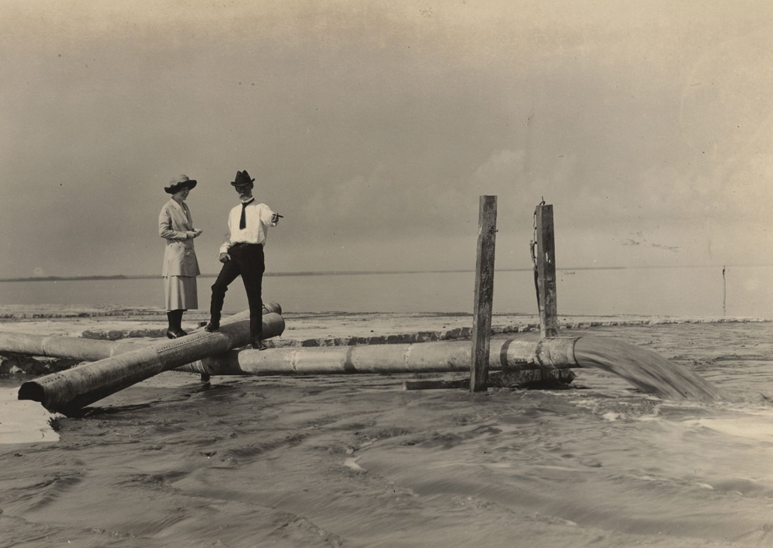
Early stages of the Florida land boom, before America entered the First World War, brought dredges to the Tampa Bay region. More than a century ago, crews began to reshape the contours of St. Petersburg. C. A. Harvey formed the Bayboro Investment Company in June 1906. By the 1910s, his workers had transformed the marshes along Salt Creek into the Bayboro district. Meanwhile, between downtown and Coffee Pot Bayou, sands dredged from Tampa Bay formed much of the North Shore district. At one time, Beach Drive north of the Vinoy lived up to its name—it sat along the beach. By 1918, homes sprouted on reclaimed lands between the beach and Beach Drive.
Tampa developers got into the act as well. Most notably, David P. (D. P.) Davis hired crews to transform marshlands south of downtown and near the mouth of the Hillsborough River into Davis Islands during the 1920s. Davis never lived to see the potential of his development. As his investments and marriage faltered in 1926, he decided the travel across the Atlantic Ocean to France that October on the Majestic, then one of the largest luxury liners in the world. During the journey to see his estranged wife, he fell overboard, though the circumstances of his death remain a mystery today. What remains clear, however, is that Davis Islands transformed the stature of Tampa, offering the Cigar City a site for its first major hospital (construction of Tampa General Hospital began in early 1926) and first notable airport (Peter O. Knight, Tampa’s main airfield between 1935 and the end of the Second World War).
St. Petersburg’s Albert Whitted Airport, opened in the late 1920s, also sits upon dredged land. Similarly, visitors to the Mahaffey Theater, the Salvador Dali Museum, and much of the grounds of the Vinoy Renaissance would have had wet ankles even at low tide before the 1920s. George S. Gandy’s original bridge opened as a private toll road in November 1924, offering the first span across Tampa Bay; dredging the long approaches on the Pinellas and Hillsborough sides of Tampa Bay for Gandy Bridge started in September 1922. Before the 1920s came to an end, C. Perry Snell reclaimed portions of the peninsula now known as Snell Isle and early efforts to develop reclaimed lands in Shore Acres began.
Another trend also grew during the land boom of the 1920s: Developers expanded the bayside of many barrier islands in Pinellas, Manatee, and Sarasota counties. In 1902, the Tate family bought the southern half of the island that became Clearwater Beach for a mere $200. The first bridge between the mainland and the beach opened in 1916 along Seminole Street and construction of the first “million-dollar” causeway that connected Clearwater with its expanding beaches began less than a decade later. By the 1930s, developers had expanded the footprint of Clearwater Beach, Sand Key, and nearby areas.
H. Walter Fuller, Albert Archibald, and David Welch developed the shorelines of western St. Petersburg, Treasure Island, and Madeira Beach during the 1910s and 1920s. Charles E. Redington brought his developments to lands north of Madeira by the 1930s. On the 150th anniversary of the Declaration of Independence, July 4, 1926, Welch Causeway opened as the first free bridge to the lower Pinellas Beaches, connecting the mainland to what later became Madeira Beach. Much of the approach to the bridge on both the mainland and beach side required dredging. In 1927, a bridge at Johns Pass connected the small settlement on the Madeira Beach side with dredged lands on lands that later became Treasure Island.
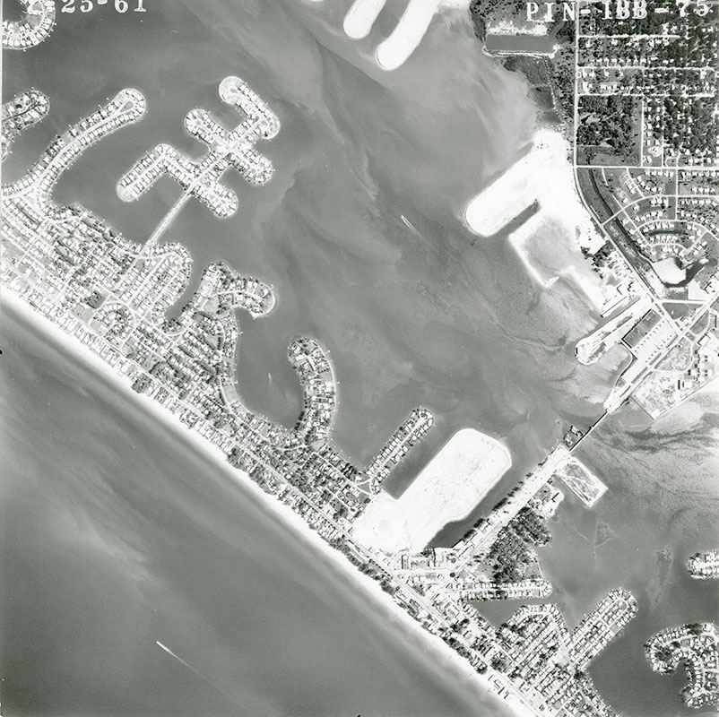
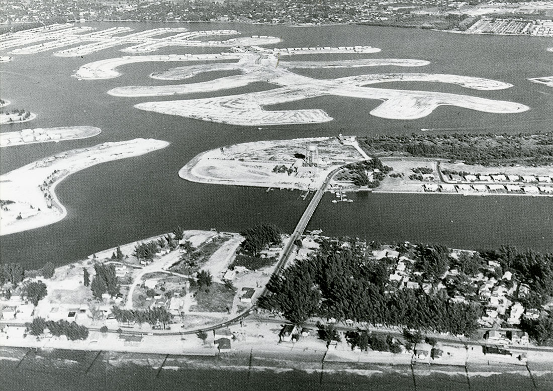
The “finger island” frenzy—the dredging of islands just wide enough for a cul-de-sac road and houses on either side—reached its heyday between the mid-1940s and 1960s. During this period, developers throughout the Tampa Bay region reaped the riches of a second land boom. New suburban communities in Hillsborough and Pinellas included waterfront destinations. As homes sprouted in the Westshore area of Tampa, nearby waterfront destinations such as Beach Park, Culbreath Isles and Stoney Point welcomed residents. Finger islands and canals transformed farmlands along the eastern shore of cental Tampa Bay into Apollo Beach during the 1950s and 1960s. Pelican Island near Rocky Point took shape in the late 1970s.
Similar transformations came to Manatee County. In the late 1950s, O. F. Quartullo had started to develop the Gulf and Bay Estates on Snead Island. Located between the Manatee River and Terra Ceia Bay, Snead Island became an area where county officials fought against Quartello’s plans to secure permission from the Army Corps of Engineers to dredge additional lands from Terra Ceia Bay in 1961. Although Snead Island never expanded as much as Quartullo had planned, finger islands did significantly transform the bayside of Anna Maria Island, just to the west, as new residences provided views of Bimini Bay with docks and navigable canals. Cortez, once a quiet fishing community between Bradenton and Bradenton Beach, also changed as developers added finger islands on both sides of Cortez Road.
Pasco and Hernando counties also got into the act. Pasco County commissioners approved dredge-and-fill operations at Gulf Harbors in August 1970. The Lindrick Corp., developer of the community, wanted to dredge an additional 1,400 acres of land south of Green Key Road and north of Flor-a-Mar and Gulf Harbor Villas in 1972. Dredging reshaped the Hudson shoreline with the creation of subdivisions such as Hudson Beach Estates, Leisure Beach, Pleasure Isles, and Signal Cove. Ironically, when developers that wanted to dredge additional lands along Signal Cove met with the Pasco County Planning Commission in 1983, some of the loudest protests came from residents of these dredged areas, who complained that new construction would harm the water quality, hurt the wildlife, and, of course, obstruct their views of the natural environment. West of Weeki Wachee Springs State Park and Shoal Line Road, canals and finger islands reshaped Hernando Beach.
Some of the most dramatic transformations occurred along the Pinellas side of Tampa Bay and within the confines of Boca Ciega Bay. The Shore Acres area, largely dormant after the end of the land boom, sprouted new islands in the postwar years, places known as much for their flooding after severe rainstorms as the nice dockside views from their backyards. Once an uninhabited peninsula known as Goat Island, the Mackle family transformed the land later named Lewis Island into Coquina Key, and gained permission to extend its presence significantly into Big Bayou during the 1950s.
Between the late 1940s and 1960s, finger islands expanded the footprints of Clearwater Beach, Belleair Beach, the Redingtons, Madeira Beach, Treasure Island, and St. Pete Beach. Dredges later connected Cabbage Key, Pine Key, and other smaller sandbars to create Tierra Verde, an island that exists largely due to the technology of dredges and the presence of seawalls. In April 1957, commissioners in Pinellas County approved the controversial Ratner Fill that later became Isla del Sol. By the time dredging ended on this site in 1961, mounds of muck filled the lagoons along lower Boca Ciega Bay to the point that many turtle grasses disappeared and aquaculture suffered.
Laws and court cases slowed the incessant dredging in our region by the 1970s. Passage of the 1968 National Estuary Protection Act offered greater protection for sensitive estuaries. A federal court case based on a local developer also brought an end to massive dredging projects in our bays. Alfred G. Zabel wanted to expand his trailer park into Boca Ciega Bay by twelve acres. After Army Corps of Engineers Colonel R. A. Tabb denied Zabel’s permit, Zabel sued in the spring of 1967. Ultimately, the government prevailed in the Zabel v. Tabb ruling of the United States Fifth Circuit Court of Appeals, when the court ruled in July 1970 that it could take under consideration the cumulative effect of dredging on the waterway. This Pinellas-based decision by the court in New Orleans had national consequences for future dredge-and-fill projects.
For much of the last century, developers sought to create residential developments that gave our bays and gulf “the finger.” During the last forty years, efforts have shifted to focus on maintaining shipping and navigational channels to support the regional economy and preserving our dynamic beachfronts and shorelines. Partnerships led by the Tampa Bay Estuary Program have improved water quality to such an incredible extent that as many acres of seagrasses are growing in Tampa Bay today as did during the 1950s – minus, of course, those that were growing on a bay bottom that now hosts housing developments.
[su_divider]